Featured Quizzes
User Quizzes
Create Quiz
Data and Charts
Word Search
Flash Cards
Badges and Games
About JetPunk
Message Board
Random Quiz
Dark Mode
Regions of North and South America - Statistics
General Stats
- This quiz has been taken 62 times
- The average score is 11 of 32
Answer Stats
| Picture | Hint | Answer | % Correct |
|---|---|---|---|
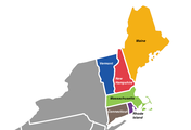 | Northeastern states where British colonies were settled. | New England | 91%
|
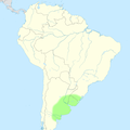
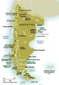 | Natural and historical region in the south of Argentina and Chile | Patagonia | 78%
|
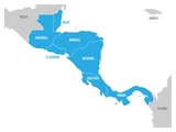 | Tapering isthmus running from Southern Mexico to South America | Central America | 76%
|
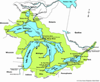 | Binational basin which is also an economic hub | Great Lakes | 72%
|
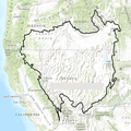
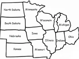 | Historical region that comprises the north-central states of the U.S. | Midwest | 66%
|
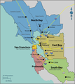 | Metropolitan area in Northern California | Bay Area | 64%
|
 | Modified low grasslands where Gaucho culture has been developed | Pampas | 64%
|
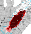 | American highlands whose inhabitants are often portrayed as isolated and uneducated | Appalachia | 55%
|
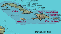 | The largest islands in the Caribbean Sea | Greater Antilles | 55%
|
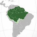 | Rainforest region delimited by the largest drainage basin in the world | Amazonia | 48%
|
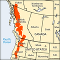 | North Pacific mountain range linked to an independence movement | Cascade Range | 41%
|
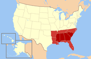 | Cultural and historical region which were most economically dependent on plantations and slavery | Deep South | 41%
|
 | A series of endorheic watersheds in western U.S., noted for its arid climate | Great Basin | 40%
|
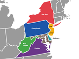 | Northeastern and Southeastern states that have their origin in the Middle Colonies of the 18th century | Mid-Atlantic | 36%
|
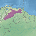
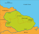 | Sparsely populated region defined by one the northeastern craton of the South American Plate | The Guianas | 34%
|
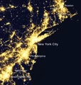 | World's largest megalopolis located in Northeast America | BosWash | 29%
|
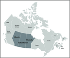 | Western territories partially covered by grasslands, commonly referred to as "Canada's breadbasket" | Prairie Provinces | 29%
|
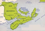 | Eastern territories known for having picturesque coastal landscapes and excellent seafood | The Maritimes | 22%
|
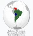 | South American trade bloc | Mercosur | 19%
|
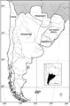 | Cultural region composed of the southernmost, template areas of South America | Southern Cone | 16%
|
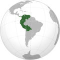 | Hispanic American countries whose republican origin is attributed to the ideals of Simón Bolívar | Bolivarian Countries | 12%
|
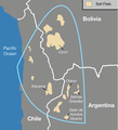 | Geostrategic region due to its lithium reserves | Lithium Triangle | 12%
|
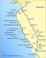 | Rugged section of the Central Coast of California | Big Sur | 10%
|
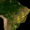
 | Semi-arid tropical ecorregion in northeastern Brazil | Caatinga | 10%
|
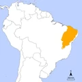
 | Natural region that extends along the Atlantic coast of Brazil | Atlantic Forest | 9%
|
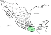 | Cultural region in south-central Mexico, which refers to the home of the Mixtec people | La Mixteca | 9%
|
 | Tropical grassland plain whose main river is the Orinoco | Llanos | 9%
|
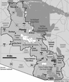 | Urban megaregion in the south of Arizona | Sun Corridor | 7%
|
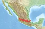 | Active volcanic arc that covers central-southern Mexico | Transvolcanic Belt | 5%
|
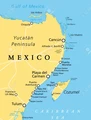 | Coastal corridor of the Yucatán Peninsula famous for its large scale all-inclusive resorts and historical tourism | Riviera Maya | 3%
|
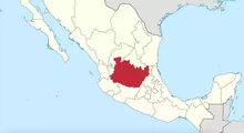 | Central lowlands which features one of the strongest economies of Mexico | Bajío | 2%
|
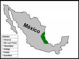 | Indigenous region along the Gulf of Mexico | Huasteca | 2%
|
No matching quizzes found
Score Distribution
Percent of People with Each Score
Percentile by Number Answered
Your Score History
You have not taken this quiz
New and Popular