Featured Quizzes
User Quizzes
Create Quiz
Data and Charts
Word Search
Flash Cards
Badges and Games
About JetPunk
Message Board
Random Quiz
Dark Mode
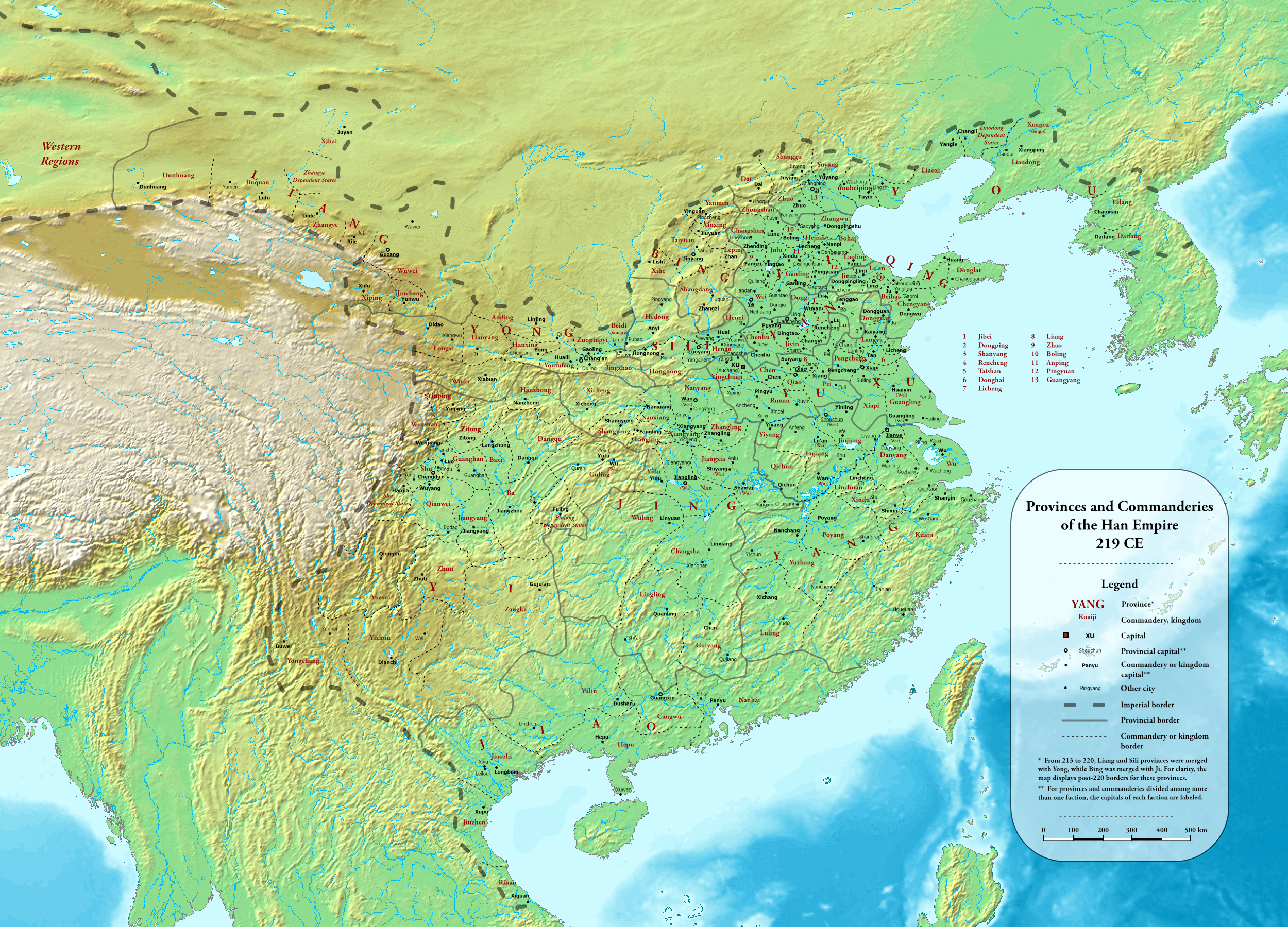
Subdivisions of Imperial China in 219 AD with a Map
With the help of a map, can you guess all commanderies and vassals of China under the Han dynasty (Eastern Han) in 219 AD?
(Largely) according to this map.
Rate:
Last updated: December 18, 2021
You have not attempted this quiz yet.
More quiz info >>
| First submitted | December 18, 2021 |
| Times taken | 557 |
| Average score | 12.6% |
| Rating | 4.86 | Report this quiz | Report |
14:00
Enter answer here
0
/ 135 guessed
Time Used
00:00
Best Time
00:00
The quiz is paused. You have remaining.
Copied!
Scoring
You scored / = %
This beats or equals
% of test takers
also scored 100%
The average score is
Your high score is
Your fastest time is
Keep scrolling down for answers and more stats ...
|
|
|
|
|
|
|
|
Save Your Stats
Your Next Quiz

Can you name the 14 countries that share a land border with China?

Can you guess the modern-day countries whose territory was occupied by Japanese troops during WWII?

Can you name the countries which had territory on the Iberian Peninsula in six different historical years.

Pin each city on the world map as close as you can. Closer = more points!
New and Popular
Historical Subdivision Map Quizzes
Quiz series by Dekkie
...
One example I could find was that Lelang and Daifang are drawn as if they extended to the Sea of Japan, and Daifang especially spanning into what is currently South Korea. There is no found evidence in current South Korea of Han administrations, and to the east of Lelang and Daifang, Eastern Ye existed in this period and thus they could not touch the Sea of Japan.
Besides, there seems to be some transcription errors (ex. Jinquan instead of Jiuquan).
But anyways, great quiz! The effort to make this kind of quiz (plus the map!) must be immense, and I appreciate it.