
The New Continent Doctrine
Last updated: Wednesday March 19th, 2025
Report this blog
Introduction
There are few terms in geography that have clear-cut definitions. Outside of "country," perhaps none of these is so nebulous as the concept of a continent. We all learned what these were in grade school, but depending on where you grew up, your idea of what counts as a continent could be wildly different. In this blog, I'll go over some common answers to the question of how many continents there are, explain why they're all wrong, and present a new model to easily classify land by continent.
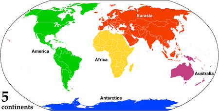
The Seven-Continent Model
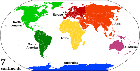
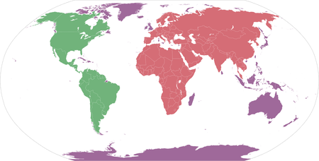
This is probably the model most familiar to JetPunk users. We get our six standard continents that you'll see in every "by Continent" quiz—Africa, Asia, Europe, North America, Oceania (referred to as Australia in the image), and South America—plus Antarctica, which is only absent from those quizzes due to a lack of countries. If you, like me, were raised in the United States, this was probably the model you were taught in school, and is the predominant model in the English-speaking world and China.
If you've never thought about continents too much before, this probably seems perfectly reasonable. The old world is divided into the three continents first mentioned by Herodotus in the 5th century B.C.E.—Europe, Asia, and Africa (which he called Libya)—while the new world is divided into North and South America by a somewhat ambiguous boundary in Panama. Antarctica and Australia are there too, and it seems natural that these big landmasses should be granted the title of continent based on the precedent set by the other five. Despite its familiarity, the absurdities of this model will become clear as we explore other options.
Side Note: Australia/Oceania
Growing up, I was taught that Australia was a continent, but New Zealand and the other Pacific islands were not a part of any continent. This is depressing. Every area of land deserves to be part of a continent, even if it's part of a landmass that just happens to be "too small" in the eyes of the Continent Classification Cabal.
Side Note 2: Zealandia
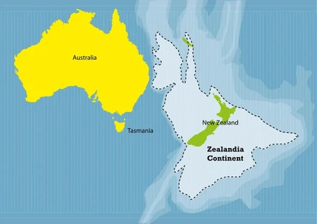
If you haven't heard of Zealandia before, there's a good reason: it's entirely ridiculous and made-up. Just look at this thing! If shallow ocean with some islands counts as a continent, then anything can count as a continent. If you want every island to be its own continent, more power to you, I guess, but we already have a word for that: "island."
The Six-Continent Model: Combined America
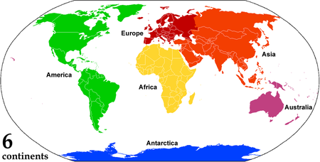
This model is common in Latin America and continental Europe. The five rings on the Olympic flag represent these continents—sorry, Antarctica, no ring for you.
America is no longer divided into North and South; we're just one big happy European-colonized continent. This model helps with the somewhat arbitrary border between North and South America we saw in the seven-continent model and leaves the connected landmass intact as a single unit. Please don't argue that the Panama Canal means that they're not actually connected. If humans digging a big ditch counts as making a new continent, then the word continent has basically no meaning.
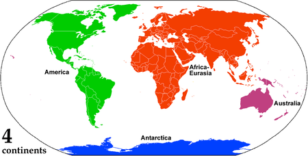
The Six-Continent Model: Combined Eurasia
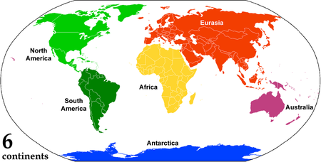
The other common six continent model leaves the Americas divided, but combines Asia and Europe. The Asia-Europe border (generally agreed to be formed by the Ural and Caucasus mountains, as depicted in the previous models) is probably the boundary that makes the least sense in the seven-continent model. All the other divisions are connected by at most a small strip of land, while Asia and Europe are just obviously attached to one another. Despite the clear cultural divisions between the two continents, if we want to use "continent" as a geographical term, there's no good reason to keep Asia and Europe separate.
This model is most common in Eastern Europe (also known as Central Eurasia) in large part to the influence of the Soviet Union. This is also the predominant model in Japan and Korea.
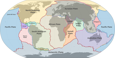
This model does a pretty good job of capturing the subterranean truth of the continents. North and South America are still on separate continents, as they are on separate plates, while the main part of Eurasia is all located on the same plate.
However, if we want to be tectonic plate purists, we'd have to face the uncomfortable truth that India and Arabia are on separate plates from Eurasia proper, and that East Africa is on a separate plate from the rest of Africa. The idea that India should be on a different continent than neighboring Myanmar doesn't quite pass the sniff test, and so this should not be the basis for our definition of a continent.
The Five-Continent Model
Here, we combine the pros of the two six-continent models. I don't have much to say about this model—we've already gone over why the changes from the seven-continent model are beneficial, and, as far as I can tell, this model is not in common use anywhere.
The Four-Continent Model
Above, I attempted to preempt pedantic comments about the Panama Canal, but there's another major canal to consider: the Suez Canal. Africa and Eurasia are, in fact, attached, and this model reflects that. Again, it seems that no one actually uses this model, but it is a clear improvement over the five-continent model.
It seems pretty hard from this point to make any meaningful changes to the map. Oceania—Australia, in the image—feels pretty distinct from Afroeurasia (my preferred name for the main landmass of the old world) due to its distance from and lack of land connection to the bigger continent, and so we can't in good conscience combine them to form Austrafroeurasia. However, there are still some changes we can make to improve our model of the continents.
What's Up With Indonesia?
The boundary between Oceania and Afroeurasia is clearly the blurriest of the continental divisions of the four-continent model. Why should New Guinea be in Oceania while Sulawesi and Borneo are Afroeurasian? The answer is that there is no good reason. New Guinea is on a different tectonic plate, sure, but we've already established that plates aren't a good rationale for what land belongs to what continent. If Australia is definitely on a different continent from Afroeurasia, then these islands must be, too.
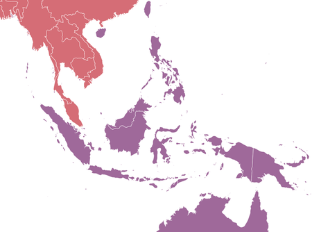
Okay, great. We've shifted the islands of the Malay Archipelago to be part of Oceania as well. But what's the difference between these islands and any other island? Madagascar isn't attached to Afroeurasia either. Surely that's not a part of Oceania, too? Well, I have news for you, friends. It is.
The Method
This is what it's all been leading up to. Let's get the easy parts out of the way first. Pick a point on land and ask yourself the following two questions:
1. Is there a land connection to Damascus, Syria? If yes, that point is on the continent of Afroeurasia.
2. Is there a land connection to Mexico City, Mexico? If yes, that point is on the continent of America.
Note that for the purposes of these questions, the Panama and Suez Canals (as well as any other relevant canals) do not count as severing what would otherwise be a land connection. South America is connected to Mexico City and Africa is connected to Damascus. Even if this weren't the case, though, one of the later points would address this and similar issues as well.
Easy enough, right? For the vast majority of points on Earth, the answer to one of those questions will be yes. If the answer to both of them is no, that means you're on an island.
It may look like all the islands in the images above are colored purple, but don't worry. Not every island is Oceania. That would be silly! Take Isle Royale, for instance. It's in Lake Superior, which is surrounded on all sides by parts of America, and so Isle Royale counts as part of America too. No room for Oceanian enclaves in other continents. Similar allowances should be made for rivers, streams, and other inland bodies of water.
3. Is the island in a lake or river? If yes, that island belongs to whatever continent surrounds the lake or river.
Well, what counts as a lake? Certainly a valid question, but beyond the scope of this blog post. You're here to learn about continents, not lakes. If someone else wants to make a deep dive into what it means to be a lake, I would be fascinated to learn more. For now, just use your brain to try to figure out what's a lake and what's not. If most people would agree that something is a lake, it's probably a lake.
Rivers are mostly the same, with some room for quibbles where they meet the sea. Inland river islands, also known as fluvial islands, are certainly part of the continent that they are inland of. Islands in estuaries are probably the least concrete part of this system, and perhaps more can be said about them in the future. The Wikipedia article for "river island" assures me that there is a definition, even if it doesn't elaborate on what that definition is. The mathematician in me is satisfied by the existence of a definition, though, and so we'll move on for now.
Inland islands aren't the only non-Oceanic islands. Let's look at Long Island. It's right there next to the mainland, and any serious attempt to convince someone that it's not part of America would probably result in you getting trampled by an angry mob of Brooklynites. But what's the fundamental difference between Brooklyn and, say, Hainan, which above I asserted was part of Oceania?
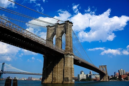
It's the bridges. Bridges are a way for the two "mainland continents" of Afroeurasia and America to expand their influence into Oceania. The Brooklyn Bridge connects Long Island to Manhattan, which is in turn connected to the mainland by other bridges. As a result, Long Island gets to stay part of America.
4. Is the island connected to either of the mainland continents by a bridge or series of bridges? If yes, the island belongs to whichever of the mainland continents it's connected to.
At this point in time, there are no bridges that connect America to Afroeurasia. If we ever bridge the Bering Strait, we might have to revise this doctrine to deal with the one mega-continent of Americafroeurasia, but we'll cross that bridge when we come to it.
Of course, this criterion raises the question of what a bridge is. Again, fascinating, but not for this blog. The only thing I have to say about what a bridge is is that a tunnel is not a bridge. Feel free to disagree, but know that you're wrong.
This ends the checklist for the method. If you answered no to every question, the land you picked is part of Oceania. Easy!
The Antarctica Problem
Before I started actually doing research for this post, I was under the impression that Antarctica is a bunch of islands all covered in ice, and therefore rightful Oceanic territory. And that's... kinda true. Here's an image of what Antarctica would look like if all its ice immediately melted:
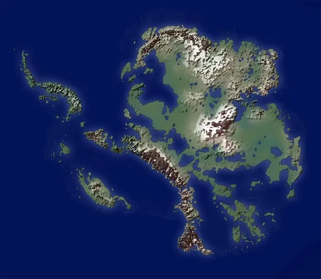
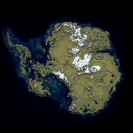
Certainly the surrounding islands would be part of Oceania, but the mainland might be big enough to be considered its own continent.
The fact is, though, that Antarctica is currently covered in ice. Does ice count as land? I think there's good reason to say no: if a piece of an ice sheet crumbles into the sea, and that ice is land, there's now just a new island floating around, which feels pretty weird. So, until someone convinces me otherwise, I'm going to say ice is not land. That means that the "land" part of Antarctica is actually a bunch of islands, and therefore belongs to Oceania.
The Antarctica situation is definitely complicated, and is the area of this doctrine that I'm most open to having my mind changed about. For now, though, I'm willing to say that Oceania needs all the help that it can get, and so Antarctica is a welcome addition to its territory.
Some Worked Examples
To get a feel for the method, let's work through the procedure together on a couple examples.
Example A: Shanghai, China
1. Does Shanghai have a land connection to Damascus? Yes! So Shanghai is on Afroeurasia.
Example B: Montreal, Canada
1. Does Montreal have a land connection to Damascus? No.
2. Does Montreal have a land connection to Mexico City? No.
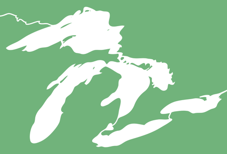
3. Is Montreal on an island in a lake or river? Yes! It's in the Saint Lawrence River, which is an inland body of water in America. Therefore, Montreal is on America.
Bonus, if you're not convinced by the riverishness of the Saint Lawrence:
4. Is Montreal connected to America or Afroeurasia by bridge? Yes! It's connected to America, and so is part of America. This confirms our findings from before, supporting the consistency of the method.
Example C: Singapore
1. Does Singapore have a land connection to Damascus? No.
2. Does Singapore have a land connection to Mexico City? No.
3. Is Singapore on an island in a lake or river? No.
4. Is Singapore connected to America or Afroeurasia by bridge? Yes! It's connected to Afroeurasia, and so is part of Afroeurasia.
Example D: Glasgow, Scotland
1. Does Glasgow have a land connection to Damascus? No.
2. Does Glasgow have a land connection to Mexico City? No.
3. Is Glasgow on an island in a lake or river? No.
4. Is Glasgow connected to America or Afroeurasia by bridge? No. Remember, tunnels aren't bridges! So the Channel Tunnel doesn't count.
Since all the answers were no, we know that Glasgow is part of Oceania.
Example E: Limassol, Cyprus
1. Does Limassol have a land connection to Damascus? No.
2. Does Limassol have a land connection to Mexico City? No.
3. Is Limassol on an island in a lake or river? No.
4. Is Limassol connected to America or Afroeurasia by bridge? No.
Since all the answers were no, Limassol (and all of Cyprus) are part of Oceania. Hopefully this will put an end to the comment debates about which continent Cyprus belongs to.
Implications
Since bridges are a defining part of the procedure to determine what continent a landmass belongs to, a landmass can potentially change continents if a bridge is built connecting it to one of the mainland continents. This is a perk of the system, not a drawback. In the fast-paced world of the 21st century, we need systems that can change with the times, and allowing the shifting boundaries of continents is the type of innovation that is desparately needed in the geography world.
Of course, no innovation is without its risks. Right now, continent-level nationalism is not a major concern, but if this force were to manifest, it could mean that bridges would become a symbol of oppression for the Oceanic people. By building bridges to unconnected islands, the mainland continents could be seen as colonizing Oceania, which could lead to bridge-focused Oceanic terrorism. If all-out war between the continents were to break out, we would see a massive boom in the construction and ballistics industries as the mainlanders would seek to build bridges and colonize while the Oceanians would do everything within their power to destroy those bridges. Oceania is a much smaller continent than the mainlands, but it's a lot easier to destroy a bridge than it is to build one. Who would come out on top? It's not my place to say.
In Summary
There are 3 continents. The two mainland continents of Afroeurasia and America, and the one island continent of Oceania, consisting of all non-inland islands not connected to the mainland by bridges.
Please leave any feedback and questions below. If you think you've come across an issue that I missed, please let me know! Novel theories often have holes, and any help in patching those up is greatly appreciated.
Although about 40 years too late...
Anyway, when I was at school I learnt the continent as Australasia rather than Oceania.
Africa is separated from Asia, of a fashion, by the Suez canal.
North and South America are divided, at this time, by the Darien Gap between Panama and Colombia.
Antarctica and Oceania are separated from everything else by water.
The only two with no real split is Europe and Asia. The border between the two is argued over, and at least two countries span both. Armenia, Georgia and of course Cyprus could be situated in either depending on your point of view.
A mega continent of Eurasia makes perfect sense. At least to me anyway.
Great Blog btw.