A Memoir of a Vancouver Roadtrip
First published: Sunday March 29th, 2026
Report this blog
I am a huge fan of roadtrips. When you choose to fly someplace, you leave your starting point and arrive at your destination, with a huge, airplane-shaped gap in the middle of the journey. It often feels jarring to step outside of the airplane, as you mind and body adjusts to being in a different place, a different climate and different weather. With a roadtrip, you get one, long and continuous journey - a journey that is sometimes uncomfortable, but which creates an adventure of itself, sometimes rivalling the experience of the destination itself.
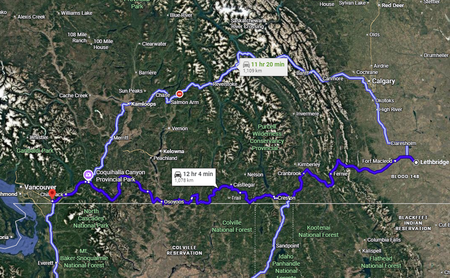
So, in May 2025 when my cousin brought up the idea of roadtripping across British Columbia, from our hometown of Lethbridge to Abbotsford, BC, the Vancouver satellite where our other cousin had recently moved to, the choice was an easy one. We faced a 12-hour drive, through all the mountains and valleys British Columbia could throw at us.
----
I quickly got to planning. Two ideas rested in my mind:
1. For starters, I wanted to free-camp the whole way (aside from a stay with my cousin in Abbotsford). Free-camping meant pulling off onto a logging road, a hiking trail or any pulloff and setting up camp. It saved on money, and meant that we could be flexible and without reservations to worry about.
2. I wanted a bucket list of places to stop by on the way there and back - but not an ordinary bucket list filled with the usual tourist attractions. Instead, I put together a bucket list of some of the stranger, more obscure places I could find. Think Atlas Obscura mixed with abandoned insane asylums and cults in the mountains. That sort of bucket list.
Additionally, me and my cousin had recently gotten into longboarding, and so we planned several trails and paths to check out with our longboards.
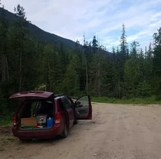
The roadtrip was planned for the end of May and the beginning of June. The day after my university graduation. It almost faced disaster when, a couple days before departure, my cousin's Audi had its wheel fall off. A very comforting development. We looked into the exorbitant costs of renting a vehicle, before settling on borrowing my cousin's family's minivan. This proved to be a good idea, as we could camp in the back of the van, but my cousin warned me that from time to time the van ignition would fail to start (the foreshadowing writes itself).
Day #1
The first leg of the journey was fairly routine for us, as we are familiar with the route. Entering through the Crowsnest Pass, the rubble of Frank Slide marked our exit from the wind-swept Albertan Prairies and our entry into the seemingly endless mountain ranges to come.
While in the Crowsnest Pass, we also spotted at least a dozen ancient cars driving the opposite way - each one looked to be from the 1920s. These weren't hot rods either, they were straight up '20s cars. Although strange, it was not to be the last time that we went back in time that day. With the highs of the journey now settling on our shoulders, the excitement and nervousness of not even knowing where we would sleep that night, we could only hope that we weren't marching towards a Great Depression of our own.
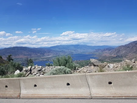
The Hill of Death
Our first major stop was in the city of Cranbrook. Cranbrook was, as my cousin dubbed it, "an alternate universe town". One one hand, the town was some of the most stereotypical North American sprawl of strip malls as far as the eye could see. On the other hand, the town had confusing roads that were both gridlike, yet didn't line up well with the highway, a man riding a bike on his back with the pedals higher than his head... and the Cranbrook Hill of Death!

Jiaozira at the bottom for scale
Wanting to stretch our legs, we decided to longboard up a paved trail, following a creek through town. The trail was fun, although in typical Cranbrook fashion, very bumpy and deteriorated. On the way up, a group of stoner dudes threw us rock-on signs with their hands. "I could get used to this place", I thought, naively.
At the top of the path, we saw a warning sign: "Warning: Steep Path, Cyclists Take Other Route".
How steep could it be? Turns out - very.
----
The path did a T in front of us, with each branch climbing two sides of a bowl shaped valley. I lived most of my life in a town with a steep valley, and let me tell you, I have never seen a path so steep before. Even walking our boards up the hill was a minor workout in and of itself.
----
So there we were, boards in hand, staring down the descent of our lives. Keep in mind we had only just begun longboarding two months prior. We were novices. A mother pushing a stroller up the path, with a second kid alongside her, eyed us as if to say "are you really going to set this example for my kids?!"
A brief flicker of intelligence graced our minds, and we decided that yes, this was too much. 3/4s of the way up the hill would be enough. I opted to go first, still feeling uneasy staring down the steep section of the hill remaining below me, board under my foot.
I sent it.
Like Rowan Atkinson's luxury Ferrari mounting from 0-60, I instantly picked up a massive amount of speed. Too much speed! I reached the bottom of the hill and suddenly got some of the worst speed wobbles of my life, my board rocking side to side under my feet. An ugly tumble into pavement seemed inevitable. Worse still, I entered a bridge over the creek, no grass to wipe out under, twigs under my board making my traction less steady. The wobbles got bigger as I anticipated the fall. But falling wasn't an option, so I leaned forwards, dug in and briefly became a man of great religion. But, mercifully, I reached the other side of the bowl, my speed dropped, the wobbles went away. I was safe.
I got off my board an ran to my cousin, warning him not to try the hill. He went anyways, and had the same near-death experience as me. We skated back to the van, had sandwiches for lunch, and left Cranbrook in the rear-view mirror.
Moyie Lake Ruins
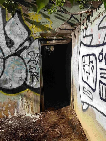
This was by comparison a short, uneventful stop. I had passed these old mining ruins on the side of Moyie Lake, just after Cranbrook, many times. They were an enigma to me, and so, graced with all the time in the world, we stopped to take a look. Only the foundations remained, covered in grafitti. I especially liked this (shallow) passageway. We walked around a bit before heading off to our next destination.
Bountiful, BC
Have you ever passed through a town and said, "this place has a culty vibe to it"? Well, what if the entire town was was founded by, and occupied by, a cult?
Bountiful is one such town. Settled in the mid-20th century by Fundamentalist Mormons, the town is best known for having been under control of cult leader Warren Jeffs until his arrest in 2007. The town is home to two groups of Fundamentalist Mormons, who practise extreme polygamy. Winston Blackmore, the current leader of one of the groups, is married to 27 wives and has fathered 150 children, for example. The RCMP is constantly investigating the town due to polygamy and marriage of teenage brides below the age of consent. Currently around 1000 people live in town.
This is a very infamous cult in Western Canada, and an example of how the mountains hold beauty, but also refuge for people who want to escape mainstream society, and even the law!
----
Needless to say, me and my cousin put our guardian angels to work when we made the turnoff from the highway, over a sweeping canyon and through the forrested orchards towards Bountiful. I cannot recommend what we were about to do, both from an ethical and a safety standpoint, but our curiosity had gotten the best of us. We had already gone back in time by one century earlier that day, and now we were about to jump back yet another century a few kilometres down the road.
----
Bountiful is easily the most erie place I've ever visited. It doesn't help that I have read all the news stories out of morbid curiosity. So when we entered the townsite, a low density, forested affair, wedged between a hill and sheer mountain cliffs near the US border, everything looked normal, and yet my hairs stood on edge. Africa by Toto was gracing our van stereo, as my cousin exclaimed: "it looks like a normal, blue-collar town". We passed by the church where Warren Jeffs had led the community just two decades prior.
Damn.
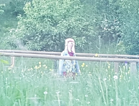
Turning another corner, we saw a second, mysterious church building tucked away in the forrest. Wanting at least some memorial from this mal-advised visit, we placed the van in park and snuck into the forest, refusing to cut the engine due to our unease. Slowly we approached the building, its lights on, yet seemingly empty. Peering through the window, I could see nothing and nobody inside. We snapped a very nervous picture, and returned to the van.
What we didn't expect, was that our Bountiful journey was not yet over...
----
When you find yourself in a secretive cult town, I can only offer one point of advice. Leave the same way you came in. This is one small piece of advice which we did not follow ourselves.
Taking an alternate path, based on a road I had seen on Google Maps satellite mode, we crawled passed a schoolhouse: empty and with a very prominent no vaping sign in front, giving us a few reluctant laughs. What we learnt that day, and something I later confirmed via Reddit posts by people who live in nearby Creston, is that the school marked a division in the town, between a group of people who had become more moderate after Jeff's arrest, attempting to rebrand themselves as "Mormon Hills" and leave a darker past behind, and a second group, who were still very fundamentalist and definitely still into mass polygamy. How this maps onto the two Fundamentalist groups I introduced earlier, I am not sure.
In any case, we were now leaving "moderate Bountiful" and entering "insane Bountiful", and we had been oblivious to it all.
----
The single through-road became more crude, made of dirt and mud. Ahead of us we saw three women walking down the road, all dressed in conservative 1800s pioneer-like attire. The formerly quiet town was no more - there were lots of people standing outside of their houses now. Shirtless men standing on their porches, eyes trained on us and our vehicle. Everybody was out and everybody was staring at us. We forgot any previous jokes about coming to town to get married, and instead excuses for why we were here began cycling through our heads. "We got lost" "We were looking for the cherry farm".
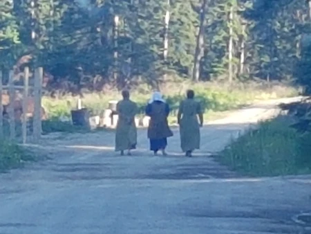
In the end, no excuses were needed. Despite the intimidating glares, no one approached us, and we never stopped the vehicle.
Just when we were breathing a sigh of relief to be leaving Bountiful, we realised something. There was something wrong with the road. We had come around a corner and we were faced with a major dilemma!
The road became mud in front of us. Thick, deep mud which would very likely get us stuck. Only the left shoulder was free of mud, but it was covered in a big pile of leaves, apparent dirt and gravel. This was one option. The other option was Bountiful, the single road heading back full of people who A. would rather be left alone, and B. knew we were here and were certainly suspicious.
My cousin, at the wheel, had made his decision. He faced the car towards the big pile, pressed hard on the pedal and gunned it.
We bottomed out. Hard.
But we made it through, our only remaining worries being if we would be leaking gas all the way back to Creston. Fortunately, the van took minimal damage and we were fine.
Camp #1
We drove through the Creston valley and up into the opposite mountains, were we arrived at a hiking trail, a location I had previously scouted out on Google Earth and marked down. It was a quiet location, just tucked off the highway enough to avoid the lights and some of the noise. A researcher was there, packing up to head back to town, and he explained to us that due to a late snowmelt combined with plentiful rain, the creeks and streams were much higher than usual for this time of year. "A swollen creek would make for good white noise" I thought to myself.
The best part about setting up camp on the first night, is that you discover all the things you forgot to pack. In our case, it was especially silly. We forgot to pack any sort of cooking oil, and the lighter which had worked perfectly when I tested it that morning in the garage, now refused to flicker at all. Our backup lighter was misplaced and nowhere in sight. Fortunately, it was a 10 minute drive back to town, where we bought a lighter from a gas station, and successfully convinced a Tim Hortons worker that we were insane, by ordering hot chocolate with a side of butter (and honey for sandwiches).

Fire and cooking oil now taken care of, we set up camp, and were delighted to see that the mosquitos had diminished from earlier, as darkness began to set it. I cooked up some disappointing tacos on the cookstove and we finished our hot chocolate.
As dusk set in, and the stars revealed themselves overhead, I noticed a twinkling light further up the hill. A camp fire! We trekked up the road a little further to introduce ourselves to our neighbours for the night, and decided the best way to approach them without scaring the living daylights out of them. As predicted, they turned out to be quite friendly. An older couple with an RV, they gave us a local's advice for other good areas to free-camp in the West Kootenay region (the region we were in). We didn't end up camping in any of those locations in the end, but meeting some fellow travellers was a pleasant way to end a very action-packed day.
Day #2
Sleep was alright in the van, with my sleeping bag and the relative protection of the vehicle shielding against nighttime temperatures in the low single-digits. I woke up at 6:00 alongside the rising sun. Leaving your sleeping bag in these conditions is never a fun endeavour, but a cup of strong black tea brought me back to my senses.
In front of us lay the towering Kootenay Pass, one of the highest passes in the country. The climb to the top was a scenic one, framed by late May snow blanketing the summit. Me and my cousin took a break in a log cabin we found on top, a cabin open for hikers, snowshoers and backcountry skiers looking to explore more of the high-altitude alpineland.
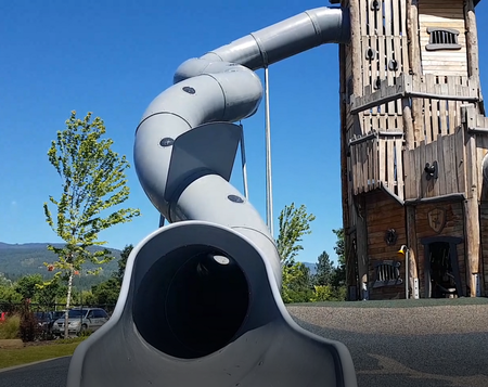
Descending towards Castlegar, we visited the newly built Millennium Park for song longboard action, and to check out Canada's tallest playground slide. In the early morning, the playground was deserted, and so me and my cousin had no problems sneaking in and climbing up the structure (which is not easy as full-grown adults). However, we chose to crawl down the awkwardly winding slide, as we discovered that the thing that has ripped out a chunk of skin on my wrist last time I snuck a cheeky run down the slide, a month prior, were massive bolts sticking out on the inside of the slide!
Ascending through the very Slavic-sounding community of Ootischenia (home to Russian Doukhobors) we continued onwards to the Okanagan Valley.
Greenwood Cemetary
Back at Moyie Lake, me and my cousin had spotted an old, overgrown cemetary above the highway. It looked truly creepy, and we had considered stopping, but due to time constraints we decided to save any cemetary crawling for later.
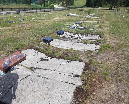
I had heard stories of Greenwood Cemetary before our trip - that it had a sinister atmosphere - due in no small part to being situated in a borderline ghost town that had peaked over 100 years ago, and continued to decline ever since. Greenwood is legally a city, as BC requires a town to have at least 5000 people before it can be considered a city. However, it has since shrunk to the point of having only a few hundred residents. Most residents in the former mining town can trace their history back to the original miners who migrated to the area.
We passed about an hour walking around the cemetary and observing the different names on the gravestones, their places of birth and the dates they were alive. I found several who were born in the early 19th Century, which seemed impressive for an area like BC, which became a province in 1871. We came across a man's grave from Virginia, who was born in the 1820s. My cousin wondered out loud "he could have fought in the American Civil War!"
Really, the most unsettling part of the cemetary was the way that some of the older graves had "settled", with the dirt caving in as the coffin decayed. This left coffin-shaped indents in the ground above some of the graves. This and the utter silence of the area, which was well removed from the highway, made for a remarkable ambiance.
----
We had places to be, however, and so we couldn't hand around too long.
The Okanagan
Descending from Anarchist mountain and its ostrich farm (which we had the delight of spotting before the illegal birds were culled), we took the winding switchbacks down to the Okanagan Valley and its arid vineyards. I have been to the Okanagan valley only a few times, and it is probably one of the least Canadian-looking places in Canada. If you showed a picture of the Okanagan to somebody and claimed it was California, or perhaps someplace in Northern Italy, I truly believe you could convince them of this. Unless it was winter. Although, even then the Okanagan receives mild winters compared to most of the country, with less snowfall.
Our dream in the Okanagan was to longboard there, and to take advantage of it being a summer paradise. In reality, it was not summer nor was it even sunny. We finished skating Osoyoos and moved up to Penticton. We passed tall vineyard sprinklers, farmers motoring along on tractors and Sikh gurdwaras. Penticton is really a lovely town, and one of my favourites in the province. It has a very relaxed summertime feel and lots of crowds and tourists, but with less of the obnoxious displays of wealth that Kelowna has. Nestled between Skaha Lake and the Okanagan Lake, the beachfront made for some compelling longboard cruising. Although this time we were racing an oncoming storm with a strong wind coming off of the lake.
Earlier, we had dreamt of swimming in the Okanagan, but the current weather helped us to make up our minds, and instead we were content with ordering ice cream from this giant peach kiosk on the beach. Another dashed Okanagan dream was our desire to buy some cider. Maybe we came in the wrong season, but all I saw were shopfronts advertising wine.
Hedley Mines
With our next leg of the journey, we pressed onwards into the mountains once more. But unlike the previous stretch of mountains, our latest scenery remained bone dry, with sparse pines dotting the landscape atop rocky mountains. It was haunting landscape, framed perfectly when Wicked Game by Chris Isaak came on throught the car speakers. We truly felt like we were in an old Western film, passing through the ocassional town, each one marked by wood frame buildings, saloons and fruit-stands.
----
Suddenly, while approaching the town of Hedley, I saw holes pock-marking a cliff wall - mines! We pulled over on the side of town, which was quiet enough that I wasn't too worried about snooping around.

Unlike most of our other stops, which I had found before on Google Maps and on online forums, stumbling upon this mine was a fluke, a stop fuelled by curiosity after seeing something new. Although tempting, we stayed on the side of the fence which did not say KEEP OUT. Channeling my inner Indiana Jones, I tried climbing up the hill to get a better look at a wooden tower structure up above, but eventually it got too steep and my footing too difficult to get any higher. And so, reluctantly, I decided to head back down the slope. On the way down, I saw something brownish copper in colour slithering right in front of my feet. I insinctively jumped, before realising what I was looking at, and I quickly called for my cousin "hey, check this out!"
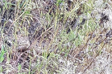
What you are looking at is a very poor quality image of a northern rubber boa! They are the northernmost species of boa snake, and are completely harmless towards humans. I felt very lucky to see one, as I don't believe they are terribly common in British Columbia, and southern BC is the northernmost limit of their range (I could be wrong about them being uncommon however).
Camp #2
The day was ending fast, and we needed to find a place to camp for the night. Although beautiful, I did not find the idea of camping in the sparsely tree-covered cowboy valley enticing, and indeed the first spot I had marked off on my map looked too open. While the majority of British Columbia is crown land, meaning that parking and camping for the night is allowed, me and my cousin both preferred somewhere a little more calm, and having more tree cover would help to ease any worries about getting disturbed in the night nonetheless.
We travelled on, with seemingly no good camping spots in the whole valley. We passed through the next large town, Princeton, and decided that we had to camp between Princeton and EC Manning Provincial Park (where free-camping would be out of the question). Fortunately, that stretch was a logging region full of pulloffs and logging roads. Unfortunately, it also came with massive ecological destruction from mines.
----
But these were not questions to dwell on at the moment, as the sun was quickly setting. A logging road abruptly jumped out on us, and, taking a chance with it, we found a flat area around 100-200 metres off the highway.
Camp was remote. Aside from the obvious resource extraction, the area felt very far away from human civilisation. If we realised we were missing any supplies this time, there was not going to be an emergency run to any gas station. Immediately, I saw signs that people had stayed here before - lumber pieces scattered all over, garbage and, disturbingly, human feces, which I covered with a piece of lumber. "Well," I thought "I guess this is home for the night".
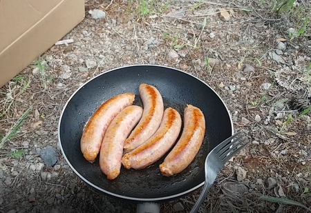
Dinner that night was sausages and rice. We cooked the sausages until they were charred on the outside, and they were delicious. We brought a box of "instant" Spanish rice, which was less convenient to cook than simply cooking rice from scratch, and (possibly due to us not following instructions properly) ended up with too much water like a stew. In spite of this, I find bush food to always taste better than food you cook at home, and tonight's dinner was no exception. It turned out better than last night's tacos, anyways.
By the time we finished eating, it was already dark, and so I collected some scrap wood and we built a fire. It was a modest campfire, but, sharpening two sticks with a knife, we roasted marshmellows and made s'mores to go alongside our hot chocolate.
Although I love looking back at some of the more adventurous moments of the trip, oddly this campfire is something I remember most fondly. There was nothing especially planned about it, but we felt resourceful setting up camp, cooking dinner and building a fire in the middle of nowhere. Also, I find you tend to get into the groove of something new, and become adjusted to it by the second day. By the second day of a trip, your body and mind become used to the trip and more in rhythm with it, but the adventure is still fresh and exciting. The second day really is a sweet spot.
----
Day #3
We woke up to another chilly morning. I could feel some clouds and increased humidity, a reminder that the ocean was slowly getting closer. We packed up and left in about half the time as the previous morning, and set out for EC Manning Park.

Gorgeous feels like a humble description for a place like this.EC Manning is a place where the valley gives way, dropping down towards the Fraser Valley (the valley Vancouver and Abbotsford are in). Clouds roll off of the mountain slopes, and the vegetation becomes lush and green (a stark contrast to the dryness of much of Interior BC and most of Alberta).
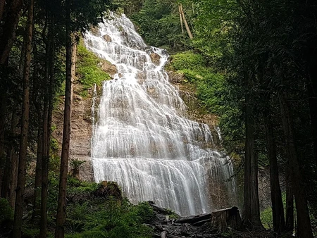
We were quite close to Abbotsford now, a little over an hour away when considering the traffic, seeing as were were about to link up with the busy Trans-Canada Highway. This gave us plenty of time to stop at Bridel Veil Falls, just outside of Chilliwack
For seemingly the first time during the trip, we were doing normal tourist stuff! This was not to last long, however. But we couldn't think of our next exploits just yet. We had come to Abbotsford to visit our cousin, after all. And so, to Abbotsford we soldiered on.
----
We arrived in Abbotsford at 9:00 in the morning. It was a very short travel day when compared to the last two. But we took advantage of our promptness to surprise our cousin (with some help from relatives). We then proceeded to get jealous of our cousin's views from his front door of the enormous Mount Baker. And then we proceeded to erase our jealousy when we found out how much he was paying for a single room in a shared house. BC really does stand for Bring Cash...
The rest of the day was much slower paced compared to the journey here. We restocked our supplies at the supermarket and shared stories of the journey with our cousin. We also visited with his fiancee when she came into town. We finished the evening by watching Monty Python and thinking ahead to what the next days would bring.
But when it came time for the next few days, we would surely be grateful to have taken a rest day!
The second and final half of the blog is soon to come!