MORE Maps that Explain Canada!
First published: Saturday December 28th, 2024
Report this blog
The Climate of Canadian Cities

When you look at a climate map of Canada (such as the one below), you will find that the majority of the country is covered in subarctic boreal forest. However, when you look at the top 250 population centres in Canada, you find a completely different pattern!
The majority of Canadian cities, from St. John's to Prince George, Calgary to Montreal, lie within the 'warm-summer humid continental' climate, with warm summers and regular precipitation. Although this is by far the most common zone in urban Canada, it is scarce amongst the largest American cities, which feature 'hot-summer humid continental' climates or humid subtropical climates in the east of the country due to warmer overall temperatures (meaning the average temperature in the warmest month is above 22 °C). Only a few Canadian cities have average summer temperatures in the 'hot-summer' zone, including Southwestern Ontario, St. Catharines and downtown Toronto (due to the urban heat island).
Meanwhile, the West coast is famous for its temperate climates, by Canadian standards. Vancouver and the Fraser Valley have oceanic climates due to their consistent temperatures, and this climate zone extends north along the coast all the way to Prince Rupert. Meanwhile, the populated east side of Vancouver Island has a 'warm-summer Mediterranean climate' due to its warm, dry summers and cool, wet winters. Victoria is notably the largest population centre in this climate.
Finally, the arid, desert-like zone of the American West extends up into Palliser's Triangle in Alberta and Saskatchewan. Technically, the arid zone even reaches all the way into parts of Saskatoon. Based on an unbalanced distribution of percipitation throughout the year, this climate also snakes its way into the valleys of Interior British Columbia, in particular the Okanagan Valley (but not Kelowna) and the Thompson Valley. A small area along the Thompson river west of Kamloops potentially contains the only true desert climate in Canada! Lethbridge is the largest cold semi-arid city in Canada, followed by Kamloops.
In the north, Yellowknife, Whitehorse and Fort McMurray all have subarctic climates, as do several Albertan and British Columbian cities and towns in the Rockies. Iqaluit is the largest Canadian city to have a tundra climate.

I decided to link a Köppen climate map of all Canadian climates for comparison. Note how prevalent the subarctic climate is in Canada, versus how common humid continental climates are in settlement patterns. A humid continental climate simply accompanies a land which can provide for a greater, more dense population than a subarctic climate could.
Also a reminder that microclimates exist beyond the scope of this map, and many Canadian cities have multiple climates within their borders. I went with the predominent climate for each city.
Source: Wikipedia (each city's page generally has detailed climate information).
The Language of Canadian Cities

This map shows every 2016 population centre in Canada (the cutoff is 1000 people), based on which language is dominant in the community. The results were not shocking (albeit pretty!) Quebec is primarily a big blue blob, with some French surpassing the borders into the surrounding provinces.
In particular, you can make you Acadia in New Brunswick, as it snakes its way down the bilingual coast, as well as the spread of French deep into Northeastern Ontario thanks to Francophone mining towns (Hearst, the blue dot the furthest west, is over 90% Francophone). There are other bilingual French-English communities on the Prairies due to settlement from Quebecois, (with Falher, Alberta having around 50% of the population speaking French) but all are too small or have too few speakers to make an imprint on the map. Edmonton and especially Winnipeg also have large Francophone quarters within each city.
English is obviously quite popular in the rest of Canada. There's not a lot of note here, other than the fact that a few towns in Quebec, including Stanstead, are majority Anglophone. Stanstead is a town situated on the Canada-US border, with the border infamously cutting through residential steets and even down the middle of a library shared between the two countries.
There are still a number of First Nations languages which are dominant in their communities, exclusively in the boreal Canadian shield region which stretches from Saskatchewan to Quebec. The geography here has served as a barrier from the Anglo/Franco dominent society, helping to preserve these languages better than Indigenous tongues to the south. There are a couple towns in northern Saskatchewan and Manitoba, and around James Bay in Ontario and Quebec, which speak Cree languages, while the three southern green dots in Quebec inhabit a more remote area surrounded by mining towns, home to the closely related Atikamekw language. The Cree languages (including Atikamekw and Innu-aimen) are some of the healthiest First Nations languages in Canada today. First Nations communities are numerous across Canada, but English is the main language in most of these communities due to the legacy of residential schools.
In the far north, the Inuit languages can be found, primarily the Inuktitut dialects. Surprisingly, most of the Nunavummiut communities with over 1000 people, as well as neighbouring Inuvik in the Northwest Territories, have a slight majority of English speakers. Additionally, while Iqaluit has a strong Inuktitut base of speakers, 40% of the population are non-Inuits and therefore speak different languages (mostly English). Nunavut as a territory is still majority Inuktitut-speaking, however. The northern region of Quebec (Nunavik) is also home to Inuktitut-speaking communities, along with a few towns in Labrador which were too small to feature here. In general, Indigenous languages in Quebec are often healthier compared with Indigenous languages in many other parts of the country.
Finally, out of nowhere, German in northern Alberta! Did you just say 'Das ist ja eine Überraschung!?' I know I said 'Das ist ja eine Überraschung!' when I found that out too. The German-speaking community is called La Crête, and has maintained German as a first language due to the presence of Mennonites. In reality, there are many groups of German speakers throughout the Prairies, particularly amongst the anabaptist Hutterite and Mennonite Christians, who migrated to the Prairies and are related to the Amish of the US. These groups vary, even internally, on usage of technology, but crucially the Hutterites speak a dialect of High German (close to Bavarian dialect) while the Mennonites of Canada speak a Low German with some Dutch influence. Hutterites typically live in communal colonies with other Hutterites on their farms, while Mennonites are a little more assimilated and typically live in towns with non-Mennonites. However, conservative 'Old-Order' Mennonites live in closely-knit communities in places like Northern Alberta, with their numbers bolstered through immigration of Mexican Mennonites (many of whom have families descended from Canadian Mennonites and thus are eligible for Canadian passports).
Religion in Canadian Cities
I made a few different maps displaying the numbers/percentages of Canadians in each city who identified with different faith groups. I was originally going to make this its own blog, but I scrapped the idea in the end. Only the top 100 population centres in Canada were recorded.

Here is the distrubution of Catholics in Canada. Catholicism is, by plurality, the largest faith-group in Canada (when Christian denominations are broken down of course). As you can tell, there are strong Catholic bases across Canada, with a concentration in Quebec and the lowest percentages of Catholics in the Lower Mainland of BC and Vancouver Island (with less than 10% Catholic people). Catholicism in the statistics is somewhat identity-based, and you will find many lapsed Catholics who identify with Catholicism, but don't attend mass or necessary believe in Catholicism, especially in Quebec which secularised after the Quiet Revolution changed Quebecois society in the 1960s (a topic for another day!)

Above is the population of Muslims in Canadian cities. Muslims, being mostly a (more recent) immigrant group to Canada, are concentrated primarily around larger cities. This is especially true in Toronto (which is 10% Muslim), with the Toronto suburb of Milton being up to 25% Muslim. Most cities in Quebec have a decently-sized Muslim community due to Quebec receiving more immigrants from French-speaking Morocco and Algeria, while in Anglophone Canada Muslims come from South Asian, African and Arab backgrounds. There are also many Persian Shi'a Muslims in cities like Vancouver, although many Persian immigrants are quite secular. In general, Muslims are more concentrated in the east of Canada.

Canada has one of the highest Sikh populations in the world, with British Columbia hosting the most significant Sikh populations of any subdivision outside of Punjab in India. Until more recently, the vast majority of Indian immigration to Canada was of Sikhs, although today there are higher percentages of Hindu and Muslim Indians moving to Canada. Historically, Sikhs were involved at the frontiers of mining communities in BC all the way to the Yukon, and even today you can find Sikh communities in more remote towns and rural areas, where few other immigrants move. Sikhs are, expectedly, concentrated around BC and in larger cities, with Abbotsford being 25% Sikh, while many Quebec cities have no Sikhs at all.

Hindus have a much more even distribution than Sikhs, as like I alluded to already, Hindus are well represented in current immigration figures - favouring big cities, Southern Ontario and job hubs across the country. Toronto, which hosts a large South Asian diaspora, is around 6% Hindu.

Buddhists are less well represented amid current immigrants, and most immigrants from China and Vietnam today lie on a scale of agnosticism to folk religion, with some being Buddhist or Christian. As the most East Asian influenced city in Canada, Vancouver hosts the most prevalent Buddhist community as well as multiple Chinese Buddhist temples.Some cities in BC and Alberta (notably my hometown of Lethbridge) host Japanese Buddhist communities as well, a legacy of Japanese immigrants from the early 20th Century, many of whom were sent to internment camps further inland during WWII.

We already touched on Anabaptists in Canada, but here's a more comprehensive map showing where they live (keep in mind we are mostly counting Mennonites here, since as I mentioned earlier Hutterites traditionally live in rural areas). There are three strongholds for Anabaptists in Canada.
1. Southern Ontario around Kitchener - this area is already known for its German community, with Mennonites of Swiss/South German origin entering Ontario in the 19th Century via Pennsylvania and many speak Pennsylvania Dutch (German).
2.Southern Manitoba in the Red River valley - Mennonites of Dutch/North German origin immigrated to this area in the late 19th Century, after living in Russia for over a century (therefore they are known as Russian Mennonites). More modernist Mennonites came to Canada from Russia, while conservative Mennonites mainly went to Latin America.
3. The Fraser Valley in British Columbia - known as the Bible Belt of BC, the area upriver from Vancouver thrives on agriculture, and supported large numbers of Russian Mennonites who moved here around the start of the post-War era. Most of the Mennonites in Russia had already left by the 1940s due to Stalinist persecution (as they were part of the landowning class), and so Mennonites came here from Manitoba and Latin America. Today, Abbotsford and Chilliwack have some of the most visible Mennonite communities in Canada at around 2-3%.

After the Mennonites we have... the Mormons! Traditionally an American religious phenomenon, Mormon settlers colonised the southernmost part of Alberta around the turn of the 20th Century, setting up a Mormon temple in the town of Cardston, the only Mormon temple in Canada for 80 years until the major cities started getting temples from the 1980s-2000s. An actively proselytising group, Mormons are present in small numbers across Canada, however their concentration is still in Alberta where they comprise over 1% of the total population. As the hub of Southern Alberta, Lethbridge has the most prominent and one of the largest Mormon communities out of any Canadian city, being around 5% Mormon. Calgary and Edmonton have slightly more Mormons numerically, while BC has the second largest Mormon community (0.3%). To the south of Lethbridge, towns founded by the Church of Latter Day Saints such as Cardston and Raymond have 60-70% of their population identifying with Mormonism, and coffee, tea and alcohol can be hard to find in this region due to religious prohibitions on them.
What are the 'Counties' of Canada?
In the United States, most states are divided into counties, providing a fairly consistent, second-level administrative division (with states making up the first-level administrative divisions). However, since the US is a federalised country, each state is in charge of divying this level of government however it likes. Louisiana, for example, divides itself into parishes (reflecting the Catholic church parishes from the French colonial days), while Alaska is divided into boroughs (including the massive Unorganized Borough which spans the entire state, has no government and is divied up into eleven areas for statistical reasons).
Louisiana's parishes are considered 'county equivalents,' while Alaska's borough's form a unique situation compared to all other US states.
....
Let's get back to Canada! Surely Canada must have a similar situation to the US...right? Well, no. Canada is also a federalised country, and so the provinces and territories are divided depending on however Toronto/Edmonton/Victoria/St. John's would like to divide the power. In fact, Canada's second-level administrative divisions, or 'county-equivalents' are so inconsistent that Statistics Canada has created census divisions in order to standardise things a little. I've seen people online claim these to be 'Canadian counties,' and I've done this on Jetpunk a couple times for simplicity's sake, but only about half of them actually follow the administrative divisions of each province and territory. The rest of them are simply lines drawn on a map, without any administrative reality. The map in questions looks like this:

Overall, I'd say Statistics Canada did an alright job of dividing the map. It is a little unbalanced (we shall see why right away) and most of the divisions which Statistics Canada created use numbers instead of names, which makes things confusing. Now, let's get a better idea of what the actual map would look like:

Provinces and territories in green feature census divisions largely corresponding to second-level administrative divisions, while provinces and territories (territory) in red have divisions constructed by census Canada.
Lets take a look at what the Canadian 'counties' really are, starting with the greens and heading to the reds:British Columbia: 28 regional districts corresponding to geographic/cultural regions. British Columbia has many different geographical regions centred around rivers and valleys. The census divisions map perfectly on to the regional districts
Ontario: 51 divisions, 49 of which match with census divisions. Ontario has counties, united counties, regional municipalities, single-tier municipalities (which have equal standing to cities, despite some of these not being very 'city-like') and unorganised districts, mostly in the north of the province.
Quebec: 104 regional county municipalities (MRC) and territorial equivalents (TE). Most are MRCs, with TEs largely being exclusive to urban regions and indigenous Cree and Inuit territories in the north of Quebec. 98 of these are census divisions, by far the most of any Canadian province.
Nova Scotia: 18 county municipalities, district municipalities and regional municipalities (the latter of which are equivalent to cities). The census divisions map perfectly on to the counties.
Yukon: None. The Yukon is unorganised outside of eight municipalities. Statistics Canada groups the entire Yukon Territory as a single unit, likewise.
Nunavut: 3 regions, which also function as census divisions. The regions reflect general geographic/cultural areas of Nunavut.
Now, let's look at provinces whose census divisions do not correspond with their second-level divisions. They have what I like to call 'imposter counties':
Alberta: 80 districts and municipalities, split between urban districts, specialized municipalities, municipal districts (counties), special areas (all of which are in an arid southwest area hit hard during the Great Depression) and improvement districts (which correspond with natural parks). Alberta's census divisions group together many of these districts.
Saskatchewan: The southern half of Saskatchewan contains 296 rural municipalities, while the upper half is administrated directly by the provincial government. Each Saskatchewanian census division groups together several rural municipalities.
Manitoba: Rural municipalities cover the bottom third of Manitoba, while the upper part of the province is unorganised, save for a small number of municipalities (such as Churchill or Thompson). The Census divisions merge several RMs together.
New Brunswick: There are 12 rural districts, whose boundaries resemble census division borders. New Brunswick also has 77 local governments, including cities, towns, villages and rural communities. Census divisions follow historical counties which no longer have any functions.
Prince Edward Island: There are 72 municipalities, but after this it all goes downhill. As you can see on the map, PEI is marked in green when it should be red. This is because PEI's census divisions follow historical counties. Within each county, there were different lots owned by (mostly absentee) landlords, where tenants could farm. This system ended in the mid-19th century, and while the counties remain culturally, they no longer have any function. Outside of the 72 municipalities (which include cities, towns, rural municipalities and one resort municipality) the rest of the island in unincorperated.
Newfoundland and Labrador: there are no administrative levels between the provincial level and the municipal level. I guess Newfoundland is similar to PEI in this way. Each of the census divisions follow cultural regions and peninsulas on Newfoundland and also Labrador. In the north of Labrador, the Inuit region of Nunatsiavut is autonomous and perhaps counts as a secondary administrative division.
Northwest Territories: there are 5 administrative regions here, based on a mixture of population and also local First Nations cultural groups. The census divisions completely ignore these regional borders and simply slash the territory in half.
-
And those are all the 'county-equivalents' of Canada! As far as I know, there are no maps which show all of these second-level administrative divisions at the same time. I'm tempted to make one, although due to the lack of standardisation across provinces and territories, it would certainly be a tough endeavour.
When Did Each City Reach 100,000 People?
As of 2021, 42 Canadian urban areas have reached 100,000 people. Hooray! (Assuming you like having neighbours). But what happens when we turn back the clock? I was interested to map when each city reached this milestone, as it gives us an idea of the different waves of population growth in Canada.

As you can see, many Canadian cities only reached 100,000 people very recently. Population booms in Ontario, British Columbia and Alberta have led to a number of cities crossing 100,000 people after the year 2000 (over half of which reached this number after the 2011 census). This has been accelerated by a Canadian population boom, although immigration is still highly concentrated in the biggest cities and almost half of all immigrants end up in the Greater Toronto Area. Perhaps a higher number of these recent migrants are regional migrants, who move from larger cities to try to secure affordable housing.
Western Canada is much 'newer' when it comes to population growth. Calgary and Edmonton reached 100,000 people after Quebec City and Hamilton, for example, but are now double the population of each city. Saskatchewan has grown slower, however, and on the other hand Winnipeg breaks the trend somewhat, as one of the older cities in Western Canada.
Ontario shows multiple population waves, with the most prominent being the postwar boom and post-2000s growth in more regional cities. Northern Ontario peaked in the 60s and 70s, with growth being much slower since. Montreal was the first to reach 100,000 people, while Toronto and Ottawa followed closely behind. In general, Quebecois cities are the most varied, with cities reaching 100,000 in various decades.
Atlantic Canada has been somewhat stagnant, with slow population growth until more recent gains in the last decade. New Brunswick and Halifax in particular have grown recently due to their (relatively) affordable real estate. The economy in this part of the country has overall not grown too fast, however, and if cities reached 100,000 people more recently, it is in part because they had been slowly approaching that number for years beforehand.
I did my best to collect data for this map, although certain cities gave me a headache, especially recently amalgamated cities (like Saguenay which didn't exist 30 years ago), or cities with a large urban area but small city limits (like Victoria). I chose to use urban areas here, as the map is already crowded enough without a bunch of suburbs included.
Source: Many Wikipedia articles from each city!
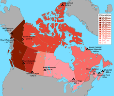
The Highest Points in Each Province and Territory
Physical geographers need not look away! Canada is a country of stunning vistas, vistas which may or may not include mountains. However, Canada's high points are not equal, and some parts of the country are much higher than others.

Unsurprisingly, the West has the tallest mountains around. Ontario and Manitoba are very flat, on the other hand! Keep in mind that 600 metres in a more maritime place general means much more relief than 600 metres so far inland. Also keep in mind that the land generally increases in elevation as you move towards the Rockies. Calgary is around 1000 metres above sea level, for example.
What if you wanted to reach every high point? How difficult would this goal be? This was my logical train of thinking... so let me tell you!
-
Prince Edward Island - Unnamed Point - PEI is definitely one of the easiest high points to bag. There is a gradual hill in the centre of the island, between the farming communities of Glen Valley and Hartsville. You simply have to park your car and walk to the top, with minimal tresspassing required. It's only a 30 minute drive from Charlottetown too, which, compared to other high points is not remote at all.
Nova Scotia - White Hill - White Hill is located in the rugged Cape Breton Highlands, and it appears to be relatively easy to reach too, although you'll have to hike a ways, potentially 20 kilometres one-way! Also, don't expect a view from the top, as the hill plateaus into a marshy, barren landscape. You have to be a dedicated high-pointer to reach this one.
Ontario - Ishpatina Ridge - located north of Sudbury, this high point is not too prominent, but rather the tallest point in a series of forested hills. The ridge is located in the Canadian Shield, a rocky region filled with lakes. It's a little remote, but can be reached via old logging roads and an over 15 kilometre one-way hike, or a canoe voyage with multiple portages.
New Brunswick - Mount Carleton - This one is more mountainous than previous high points, although it's also one of the easiest to bag. Mount Carleton is an Appalachian peak with a well-maintained hiking trail. The trail climbs 500 metres above the surrounding landscape to a lookout cabin precariously perched on top of the mountain. The hiking trail is only a 10 kilometre loop, and can be completed in under 5 hours.
Manitoba - Baldy Mountain - Located on the Manitoba Escarpment, a series of hills created by ancient glacial movement, Baldy Mountain is perhaps the easiest high point to reach. Located in a forest of pine and aspen trees, you can drive right up to the summit, which is clearly marked by a lookout tower on top. The hill itself is very gradual, but the lookout tower helps you to see over the surrounding landscapes.
Saskatchewan - Unnamed Point - this is the last of the 'easy' high points! The high point is located on a plateau just south of the Cypress Hills, the most hilly part of Saskatchewan. The high point itself is very close from a road, but it is located in a privately owned field with absolutely no views to speak of! Unless you're determined to reach this high point, you're better off sticking to the more scenic Cypress Hills.
Newfoundland and Labrador / Quebec - Mount Caubvik / Mont D'Iberville - two birds with one stone! Well, it's not quite so easy. This is a single mountain by the way, only both provinces gave the mountain different names. Mount Caubvik is both the first remote mountain and the first mountain to entail a perilous journey to those who try to claim these two high points-in-one. For starters, Mount Caubvik is far, far away from any settlement, with the closest one being an Inuit village 100 km away in Quebec. As a result, you have to hire a bush plane to take you close to the mountain's base. Mount Caubvik is also the first 'big mountain' highpoint, with the hike climbing over 1300 metres from the base of the mountain and involving a pretty technical rock scramble. With the trip to the mountain already being pretty expensive, you also have to deal with unpredictable weather at all times of the year, and so even if you make it here, there's a good chance you'll have to abandon your attempt.
Nunavut - Barbeau Peak - you can safely say you'll probably never visit three places in your life: the surface of the moon, the botton of the Mariana Trench and the summit of Barbeau Peak. Thought Mount Caubvik was remote? This mountain redefines the very word remote. Barbeau Peak is situated on the top end of Ellesmere Island, with the closest human settlement being the near-mythical weather station of Alert, at 82° North. If you are willing to spend thousands of dollars to reach here (by hiring a plane in Resolute, 700 kilometres south), it is a 1000m snow/glacial climb to the top, climbing over thin ridges. The entire mountain is covered by permanent ice and snow.
Northwest Territories - Mount Nirvana - named by passing American hippies who stumbled upon the place when their Kombi took a wrong turn on the Hippie Trail, thair first words upon marvelling on such an otherworldly giant were 'wicked, dude'. Mount Nirvana takes things to higher highs in the Nahanni parks system. The mountain itself is tough to reach, although nowhere near the craziness of Barbeau or even Caubvik. You can hire a helicopter from Watson Lake, YT, but you can also do what one of the guys on Peakbagger.com did and drive from the Yukon to the Tungsten Mine in the Northwest Territories just across the border in the Mackenzie Mountains. From here, the madman paddled downriver to the mountain, and, after summiting it, hiked back for a week until he reached Tungsten. The ascent itself climbs around 1600 metres and involves rock climbing. Not for the faint of heart.
Alberta - Mount Columbia - Now we're approaching ginormous territory. The Rockies are not, in fact, the tallest mountain range in Canada, with the Coast Mountains and the St. Elias Mountains ultimately reaching further into the skies. Despite the ascent being around 2300 metres, with a 19 kilometre trek one-way, the actual climb is a simple glacier climb and isn't too technical. Despite this, glacial traversal is still quite dangerous, so know your skills before you head out here, and rope up with a hiking buddy. Your legs will be sore after this one!
British Columbia - Mount Fairweather - whoever named this mountain was crazy! Apparently, James Cook encountered good weather during the day he spotted this mountain, and the rest is history. What makes this mountain of the St. Elias mountain range so impressive, is that it is right next to the Pacific Ocean, separated only by the thinnest portion of the Alaska Panhandle (who shares the peak with BC). Being so close to the ocean gives these mountains insane amounts of relief! The mountain is best reached by air, although a water approach is possible, and at this point we are reaching Himalayan levels of difficulty. Poor weather conditions make traversal difficult, and it takes an arduous, near-4000m climb involving snow, glacial and ice climbing in order to reach the summit. When you get closer to the summit, the crux of the climb comes in the form of a near vertical snow climb, with significant exposure and no forgiveness if you slip. The descent is even scarier on these kinds of terrain due to fatigue. Most attempts on Mount Fairweather are unsuccessful due to the crazy, harsh weather conditions, in fact.
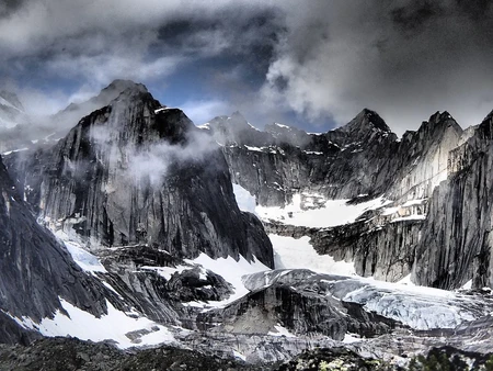
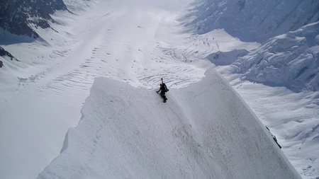
Yukon - Mount Logan - Mount Logan is hidden away from sight, if you're trying to view it from ground level, tucked away behind the St. Elias Mountains on the foreboding Kluane icefield. You have two options: walk hundreds of kilometres on the icefield to reach the mountain, or fly onto the icefield closer to the mountain. Mount Logan is another peak of Himalayan proportion, entailing an over 5000 metre climb from base to peak, and it has several routes with varying difficulty, each one involving technical ice/snow/glacier climbing. A particular ridge, the Hummingbird Ridge, has only ever been climbed once due to its difficulty. I have added a picture of another ridge to show you what to expect if you decide to finish your high points journey :)
What Time is it in Canada?

I like this map a lot because it clearly shows time zones, which places practise Daylight Savings Time (DST), and what time they are in during the summer versus the winter. These details get confusing very fast otherwise!
What I find interesting about time in Canada, is that Canada is vast enough that many Canadian provinces and territories have multiple time zones. Note that DST is not considered to be the 'default' time, even though it's used for the majority of the year.
Pacific Standard Time (-8) - used only in the 'BC heartland' (British Columbia west of the Rockies).
Mountain Standard Time (-7) - very widespread, used in Alberta, the Yukon, the Northwest Territories, a third of Nunavut and parts of BC.
Despite being the westernmost city in all of Canada, Whitehorse follows MST during the winter. However, it doesn't practise DST and synchs up with BC in the summer. BC's Peace River region follows the same practice, as does the Creston Valley in the Kootenays, which synchs with the West Kootenays in the summer and the East Kootenays of BC in the winter. Lloydminster is a city split between Alberta and Saskatchewan (as in, it's uniquely administered as one municipality, shared between two provinces), so it stays with Alberta year-round to avoid headaches.
Central Standard Time (-6) - used by Saskatchewan, Manitoba, westernmost Northwest Ontario and a third of Nunavut (the Hudsons Bay coast + Resolute in the far north).
Saskatchewan doesn't observe DST, so it is in line with Alberta in the summer (thus ending Lloydminster's excile and reconciling it with Regina. However, in the process, poor little Flin Flon and Creighton are separated from Regina. A true tragedy. Whoever drew the borders of Saskatchewan must have done it before having his or her morning coffee, as Flin Flon is yet another city which is severed by provincial boundaries, despite being one administrative unit. Most Flin Flonians live in Manitoba, although again to save headaches, the Saskatchewanian portion of Flin Flon and neighbouring Creighton observe DST, following Winnipeg's lead.
Eastern Standard Time (-5) - Covers most of Ontario and Quebec, plus the eastern third of Nunavut.
The Eureka Research Station on Ellesmere Island doesn't follow DST, as does Southampton Island in Nunavut, and the small communities of Atikokan and Pickle Lake in Ontario (the latter of which being the northernmost community in Ontario which you can reach by road). Along with PST, EST is the most commonly referenced time zone when events like sports games are scheduled on TV, and over 50% of Canadians live in this time zone.
Atlantic Standard Time (-4) - basically the Maritimes plus most of Labrador. The Magdelan Islands, which are part of Quebec, but closer geographically to Nova Scotia and Prince Edward Island, follow this time zone too.
The far northeastern coast of Quebec, including Blanc Sablon, follow this time zone year round, meaning they are in synch with the Maritimes in the winter, and the rest of Quebec in the summer.
Newfoundland Standard Time (-3.5) - this is Canada's most interesting time zone. Covering the island of Newfoundland, as well as some outports on the coast of Labrador (which historically and culturally are kind of like a mainland extension of Newfoundland), any regionally specific time zone which has partial hours like this is pretty interesting. The reason behind such a specific time zone harkens back to the days that Newfoundland was a separate dominion, and not a part of Canada. This time zone survived, despite attempts to change it by half an hour to synchronise it with the other Atlantic Provinces. Broadcasts remind Newfoundlanders that programs are at 'X time AST, half an hour later in Newfoundland.'
Although Blanc Sablon is culturally and linguistically related to the southeast coast of Labrador, with roads connecting it to Labrador and not the rest of Quebec, based on the map it appears that you will jump 1.5 hours when you cross the border in the summer. Additionally, despite most Newfoundlanders living east of the French territory of Saint Pierre and Miquelon, the territory is confusingly half an hour ahead of Newfoundland.
And That's a Wrap!
Those are all the maps I got for you guys this time. As previously mentioned, I collected these maps/data over a period of time, excluding of course the two Wikimedia maps. I was able to add a lot more detail this time compared to last time. I'll likely make a similar blog, but for Australia. I can't promise it will be out too soon. Have a Happy New Year you guys, and until next time :)
Heck, I even got inspired to do something similar for Greece, but I don't know. We'll see
Thanks for the shoutout to Mennonites. This year we are celebrating 500 years since the Anabaptist movement began in Switzerland. The celebration in Zurich this spring will include a performance of a new choral work composed by me. The text is in one of the High German dialects you mentioned.