
Most Frustrating Country Borders
Last updated: Wednesday May 28th, 2025
Report this blog
What Is An Annoying Country Border?
An annoying country border is a country's border which does not appear as appealing to the human eye. It can be a man-made border or a natural border. No country is safe from these types of borders.
Papua New Guinea and Indonesia
Papua New Guinea and Indonesia's border would have been a satisfying straight line. Instead someone had to go in the middle of that line and make it weird before going back to a straight line
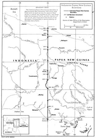
As you can see it was following a parallel then a river came into play and they decided to put the border there before coming back to be a straight line. The border between the countries have a lot of history in it with the island being split up between 3 different empires.
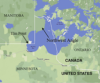
US-Canada Border - Northwest Angle (Minnesota)
This one annoys me less because it is iconic on all American maps. The border accident is in Lake Of The Woods County in Minnesota. The border was due to a survey error and maps of the area being very inaccurate. About 17 people live on that land that is not connected to the rest of the US. Still annoying enough to be on here. This mistake has made it a very iconic feature of the US (Minnesota dipping into Canada)
Brunei-Malaysia Border
If you look closely, then you will realize that Brunei is split in two. Not only is this annoying, Brunei's shape is also pretty bad as well, but that is just an opinion and is not important.
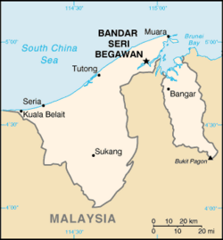
"Of the total land border length of 528.45 km, 207.3 km was determined through five agreements between Brunei and Sarawak from the British colonial era, which the two countries agreed to affirm in the "Exchange of Letters" on 16 March 2009. In the Exchange of Letters, the two countries also agreed to use the watershed principle to determine the remaining undelimited portions of the border." The border came this way from 5 agreements.
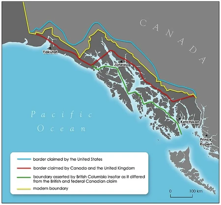
US-Canada Border (Alaska
You see the little panhandle that Alaska has? Well it is pretty bad. While the panhandle is important, containing Juneau, it was disputed over for a long time. It gets really thin and then goes big again. Though iconic in the state and the US, it makes you think if we really need it because it is so mountainous.
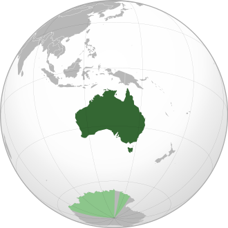
Australia
Australia is a strange continent. My main thing is Cape York Peninsula. It looks so straight on maps but in reality, it is bumpy. I just can't think of Australia without also picturing the non-existant straight line. This is majorly due to map quality but it would be nice if the peninsula was a straight line.
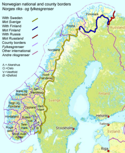
Finland-Sweden-Norway
The main issue is Finland. The weird way that Finland curves making a "Panhandle" is weird. The point in the middle is called the Three Point Cairn (It is just a fun fact). Part of this border with Norway is a river and that explains the dip in Latitude but not the Panhandle. It is just a weird oddity of these 3 countries.
Bangladesh-India
Bangladesh literally jets into India. That leaves a tiny strip of India land between Bangladesh and Nepal before opening back up into a big land mess.
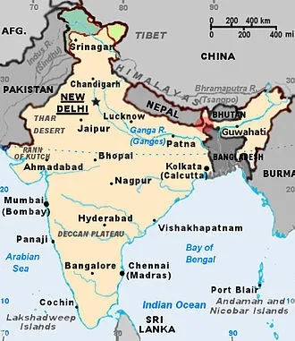
The Radcliffe Line was published on 17 August 1947 as a boundary demarcation line between the dominions of India and Pakistan upon the partition of India. It was named after its architect, Sir Cyril Radcliffe, who, as chairman of the Border Commissions, was charged with equitably dividing 450,000 square kilometres (175,000 sq mi) of territory with 88 million people based on religious lines.[2] This involved the partition of the Bengal region, which resulted in transferring East Bengal to Pakistan,[3] which was later liberated in 1971, thereby Bangladesh continuing to share the same line as the border with the Indian Republic (Gotten from Wikipedia)(Blue words are not supposed to be there)
Croatia-Bosnia and Herzegovinia Border
Croatia was pretty mean with this border. The Neum Strip allows Bosnia and Herzegovinia access to the Mediterranean Sea, which is only 20 kilometers or 12 miles long!
The Neum corridor dates back to the Treaty of Karlowitz of 1699, whereby the Republic of Ragusa was separated from the Dalmatian possessions of its rival Venice by two buffer zones ceded by Ragusa to the Ottoman Empire to prevent the possibility of Venice invading via land:[5][6] north of its territory is Neum and the bay of Klek, and south of its territory is Sutorina with the port of Herceg Novi on the Bay of Kotor, part of Montenegro since 1947 (later the topic of the now-resolved Sutorina dispute).
Germany-Switzerland Border
At large, this border is fairly okay, however, Busingen, Germany, is surrounded by Switzerland. How did it get like that?
In the Middle Ages Büsingen was part of the Landgraviate of Nellenburg, whose Landeshoheit came under Habsburg (Austrian) control in 1465. From then until 1805 Nellenburg formed part of Further Austria, a collection of various scattered Austrian possessions in Swabia. Austrian sovereignty did not go unchallenged by the Confederate Swiss of neighbouring Schaffhausen; an incident in 1693 in which Austrian feudal lord Eberhard Im Thurn was abducted and incarcerated by Swiss authorities, and the subsequent diplomatic dispute, played a particular role in the village being kept away from Swiss control.
Spain-Morocco Border
I know what you may be saying, "PontiacLover, they are separated by the strait of Gibraltar, how can they share a border?" And my answer to that is That Is Why It Is Listed Here.
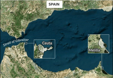
The history of this goes back to when Ceuta was conquered by the Portugese. Following the Reconquista of the Iberian Peninsula, Spain looked south to the North African coast, capturing Melilla from the Sultanate of Fez in 1497, with Portugal's blessing. Spain took the then-island of Peñón de Vélez de la Gomera by force in 1508, with Portugal recognising this claim the following year with the Treaty of Cintra.[1] Retaken by the Kingdom of Fez in 1554, Spain reconquered it in 1564, and it has remained in Spanish hands since that time
Chile-Argentina Border
Chile is one of those weird countries that likes to hug the border of the ocean. This stops Argentina from having access to the Pacific Ocean. Although that is weird, the part I am focusing on is the island of Tierra del Fuego.
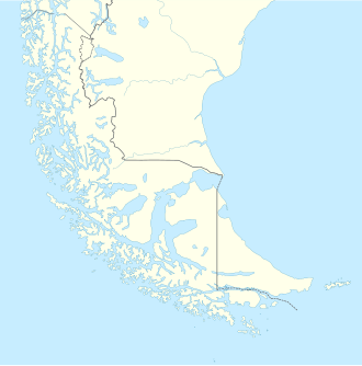
In 1945, a division of Chilean CORFO (Spanish acronym for Production Development Corporation), engaged in oil exploration, discovered oil in northern Tierra del Fuego. Extraction began in 1949 and, in 1950, the Chile state-owned ENAP (National Petroleum Company). Until 1960, most oil extracted in Chile came from Tierra del Fuego. During the 1940s Chile and Argentina lodged their Antarctic claims. In the 1950s, the Chilean military founded Puerto Williams. In the 1960s and 1970s, sovereignty claims by Argentina over Picton, Lennox, and Nueva Islands in Tierra del Fuego led the two countries to the brink of war. In 1986, the Argentine congress decided that the Argentine part of Tierra del Fuego should be a new province. This happened in 26 April 1990
Ireland-UK Border
Northern Ireland cuts right into Ireland making Ireland look a little funky. Northern Ireland isn't even further north than Ireland.
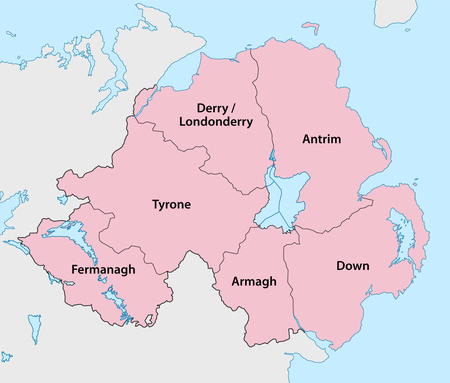
The area remains part of the UK after historical decisions made after the Irish War of Independence in 1922. Nonetheless it is still a weird border.
Vatican City/Holy See-Italy Border
The Vatican City, or the Holy See, is the worlds smallest recognized country. It's only bordered by Italy, even more so the City of Rome.
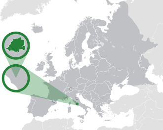
The Vatican City is not even as big as a city. It has a bunch of weird little pointy bits in it made from the Vatican Garden. On a side note, the Vatican City is almost 100 years old (96)
Senegal-Gambia Border
The Gambia is a small country in Africa that touches the Atlantic Ocean and is less than 50 kilometres (31 miles) wide at its widest point. Senegal surrounds The Gambia except for the narrow stretch of the Atlantic Ocean
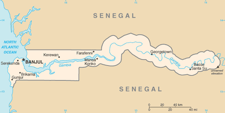
Gambia was a colony of the British while Senegal was a colony of the French. Agreements helped shape how the two countries look today.
You really like panhandles don't you?
Part of the UAE is in Oman that is in the UAE.