
County Overviews 10#
Last updated: Friday July 25th, 2025
Report this blog
Hello everybody and welcome back to part ten of the County Overviews! A milestone! I'm going to test this new format and tell me if you guys like it, again. Today, we are doing Ocean, Erie, Montgomery, Berkeley counties, all suggested by my patrons. So let's go!
OCEAN COUNTY (trumpit)
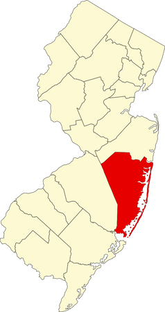
Ocean County is a county located in eastern New Jersey along the Atlantic coast. Its county seat is Toms River, though its largest settlement is the Lakewood Township. It is named after the Atlantic Ocean and was founded on February 15, 1850.
(2022 Data)
Population: 655,735
Total Area: 915 mi2
Population Density: 1,043.68/mi2
Largest Age Range: 65+
MHI: $81,152
Poverty Rate: 10.5%
Largest Sources of Immigrants: India, Dominican Republic
HISTORY
Centuries before Europeans colonized, the Lenape, who were hunters and gatherers, lived in the area. In the early 17th century, Dutch explorer Cornelius Hendrickson landed on the area, claiming the land as Dutch territory. In 1664, after the Dutch surrendered the land to the British, Duke James of York renamed the territory to "Albania" and gave it to two friends, Lord John Berkeley (given the western half) and Sir George Carteret (given the eastern half). When Carteret died, the eastern half was sold off to pay for his debt, then bought by the Proprietors, giving access to settlement for Europeans. In 1702, the territory was renamed to New Jersey by Queen Anne. Eventually, the county was officially established on February 15, 1850 as New Jersey's penultimate county from Monmouth County.
MISC. AND FUN FACTS!
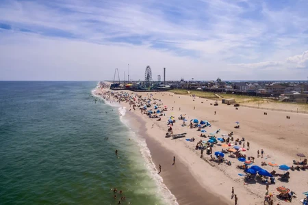
In terms of total area, Ocean County is the largest county in New Jersey, but gets beaten by Burlington County when calculating land area. It is the fastest growing county in the state. In 1970, its population was 208,470, but in 2020, its population was 637,229 (205% increase in 50 years!). The county is mostly Republican. Visit the Seaside Heights, Long Beach Island, Point Pleasant Beach, and the Six Flags Great Adventure if you find yourself in the county.
ERIE COUNTY (cathlete)
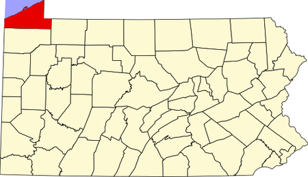
Erie County is a county located in northwestern Pennsylvania, forming the state's coast on Lake Erie, named after the Erie people, hence the namesake. Its county seat is Erie, which is also its largest city. It was founded on November 7, 1803.
(2022 Data)
Population: 267,689
Land Area: 799 mi2
Population Density: 355/mi2
Largest Age Range: 50+
MHI: $56,489
Poverty Rate: 15.4%
Largest Source of Immigrants: India, Dominican Republic
HISTORY
Before Europeans arrived, the Erie people lived in the area for centuries. Then, the French, British, and later the Americans colonized the areas during the 18th century. New York and Pennsylvania both claimed the territory near present-day Erie county, so no official boundary was able to be established until the federal government intervened. In the end, Pennsylvania was able to purchase the territory, known as the Erie Triangle. Erie County at first was established on March 12, 1800, but it, along with four other northwestern, Pennsylvanian counties, couldn't sustain themselves. So, an administrative organization was held in Meadville, Crawford County to temporarily govern the area. From this, Erie county was able to elect its first county officials in 1803.
MISC. AND FUN FACTS!
The county was at first settled by Yankees and New Englanders, and due to this, Erie County culture is more similar to New England culture than it is to Pennsylvanian culture. The county was also part of the Underground Railroad as a way to Canada. On August 28, 2003, a man named Brian Douglas Wells, who was a pizza deliveryman, robbed a PNC Bank with a bomb collar strapped to his neck. According to this plan, Wells, and two other accomplices wanted $250,000, and once the money was received, Wells was given a set of clues to disarm the bomb. The crazy part is that Wells was part of this mission, and the accomplices told him that the bomb was fake. However, once police apprehended Wells and the bomb reached zero, it exploded, killing Wells instantly. Erie County is swung between Republican and Democratic, though prior to 2016, it was Democratic. See the Presque Isle State Park, Erie County Public Library, the Warner Theatre, and Waldameer Park in the county.
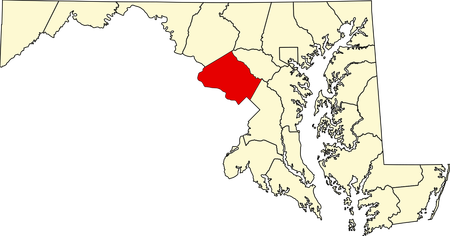
MONTGOMERY COUNTY (Ptcairn)
Montgomery County is a county located in central Maryland. Its county seat is Rockville, but its largest settlement is Germantown. It is named after Richard Montgomery, a military officer during the American Revolutionary War. It was founded on September 6, 1776.
(2022 Data)
Population: 1,052,521
Land Area: 493 mi2
Population Density: 2,134.38/mi2
Largest Age Range: 35-49
MHI: $118,020
Poverty Rate: 7.2%
Largest Source of Immigrants: El Salvador, India
HISTORY
Prior to European colonization, the land was a vast swamp that was fed by the Potomac and Patuxent rivers. The Piscataway, Susquehannock, and Seneca lived in the area. When Jamestown was established in 1607, Captain John Smith probably explored the area during his expeditions on the Chesapeake Bay and Potomac River, being the first to do so. The land was eventually granted to the Calvert family by King Charles I. In 1688, it was then given to Henry Darnall, a wealthy Marylander. He had no intention to sell the land, but instead secured grants from colonial leadership and then sold his land in pieces to settlers. Around 1715, the first settlers came into the area, many of whom were English, Scottish, German, or Quakers. Most of them were farmers who owned slaves. As the population grew and British taxation was violent, many people wanted independence. By 1776, the people across the 13 colonies wanted a strong U.S. federal government with each colony maintaining and governing its local affairs. Thomas S. Wootton wanted to split the large Frederick County into three counties. From this, Montgomery County was founded on September 6, but came into existence on October 1.
MISC AND FUN FACTS!
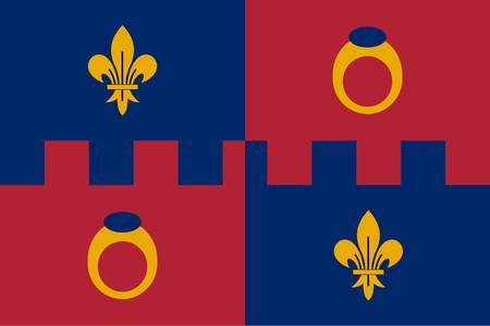
Many locals in the county refer to it as "MoCo," which is an abbreviation of Montgomery County. The county's motto is Gardez Bien, meaning "Watch Well." It, personally, has a very cool flag, especially for a county. Montgomery County was one of the first counties in the U.S. to not be named after a British referent. It is one of the most populated counties in the country, ranking 44th as of 2024. Montgomery County also ranks high in the highest median household income across counties and is first with having the largest percentage of people over twenty-five with a post-graduate degree. It has a larger nominal GDP than Tuvalu. The county is swung heavily towards Democratic. See the Brookside Gardens, Glenstone Museum, Rockville Town Square, the Billy Goat Trail, and many other attractions if you find yourself in this wonderful county.
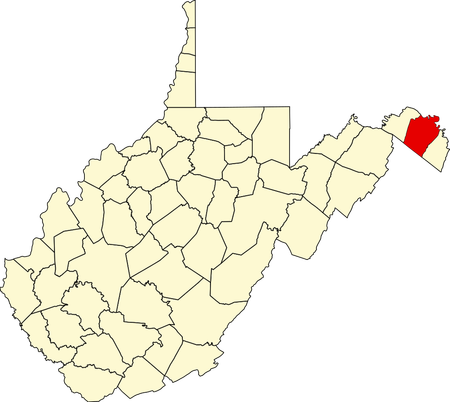
BERKELEY COUNTY (PontiacLover)
Berkeley County is a county located in the eastern panhandle of West Virginia, being the second easternmost county in the state. Its county seat is Martinsburg, which is also its largest city. Its namesake is disputed. Some say it is named after Norborne Berkeley, an English colonel, or William Berkeley, Virginia's first governor. It was founded on May 15, 1772.
(2022 Data)
Population: 129,490
Area: 321 mi2
Population Density: 403.4/mi2
Largest Age Range: 20-49
MHI: $70,829
Poverty: 10.9%
Largest Source of Immigrants: Mexico, Germany
HISTORY
Before colonizers, many Native American tribes lived in the area, such as the Huron. Then, during the 17th century, the Iroquois drove the Hurons out of West Virginia, using the state as hunting grounds. Then during the 18th century, the area near present-day West Virginia's panhandle was inhabited by the Tuscarora (then joining the Iroqious) and later the Shawnee. 16-year-old George Washington surveyed the area and found springs that were believed to have medical benefits, attracting natives and Europeans alike. Then came after the French and Indian War, where the natives in the region viewed the Brits as a threat. In the Summer of 1763, Ottawa chief Pontiac led raids on British forts near the Great Lakes region; Shawnee chief Cornstalk led similar raids on western Virginian forts, moving up north to the Shenandoah Valley (where present-day Berkeley County and its vicinity resided). The raids ended when British forces under the command of Colonel Henry Bouquet defeated Delaware and Shawnee forces in western Pennsylvania on August 6, 1763. Eventually, Berkeley County was created on May 15, 1772 by an act of the House of Burgesses from Virginia's Frederick County, becoming West Virginia's second-oldest county after it seceded from Virginia.
MISC. AND FUN FACTS!
Berkeley County used to be West Virginia's entire panhandle until Jefferson and Morgan counties were created. Martinsburg, Berkeley County's county seat, was very important for the Baltimore & Ohio Railroad as the main line ran through it. This was crucial during the American Civil War, as it carried men and military supplies on both sides. The county is skewed towards Republican. Visit the Sleepy Creek Wildlife Management Area, the Adam Stephen House, the Hedgesville Historic District, and many other recreational and historic sites in the county!
Epilogue
I hope you enjoyed and learned something for the tenth blog of the series! A new milestone has been made! Hope you learned something!
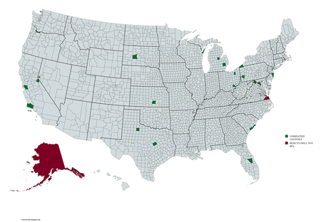
Here's the current list of upcoming counties:
11# - Tarrant County, Texas (KiloNova)
11# - Middlesex County, New Jersey (Noivern)
11# - Pennington County, South Dakota (FlabberBapper)
?? - The Washington Counties (Rockum99)
Again, you can recommend a county and you'll be on the list! I'll also start adding a map of the completed counties I did and counties (or county-equivalents) that I unfortunately won't do because they're quite dubious.
Nice blog ofc
I did a little research, I would have loved that there was a county in Montana called Hannah, just for the pun and the fact that Hannah is my daughters name. But alas, no counties at all in US with that name.
So I thought I'd try my name, and voila, Can you please , at some point, highlight Graham County in (it's a choice between Texas, Arizona, or North Carolina) decisions, decisions........North Carolina!
Please can you do Graham County, NC
Thank you!