
County Overviews 11#
First published: Friday April 24th, 2026
Report this blog
Hello everybody and welcome back to part eleven of the County Overviews! Not much to say here. We are doing Tarrant, Middlesex, Pennington, Morgan, Lincoln, Graham, and Nassau counties, all suggested by my patrons (epic people). Uh... it's been half a year since the last one. Uhh, happy late Christmas and New Years baby... and Valentine's Day and St. Pat's Day (okay genuinely it has been almost a year since the last one; I need to stop procrastinating)! Haha... Anyway, let's go!
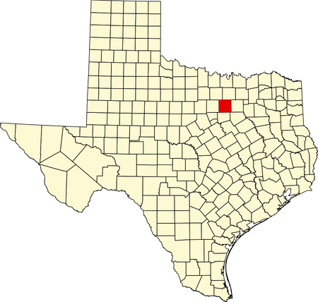
TARRANT COUNTY (KiloNova)
Tarrant County is a county located in northeast Texas. Its county seat is the well-known Fort Worth, which is also its largest city. It is named after Edward H. Tarrant, a Texan representative, and was founded in 1850.
(2022 Data)
Population: 2,154,595
Total Area: 902 mi2
Population Density: 2,388.7/mi2
Largest Age Range: 20-34
MHI: $76,285
Poverty Rate: 11%
Largest Sources of Immigrants: Mexico, India
HISTORY
Before the Europeans colonized, it was believed that the Tonkawa and Caddo people were some of the first people in the area. By the 1700s, the Comanche, Kiowa, and Wichita peoples moved into the region. Then came the settlers, who fought with the native people. The Battle of Village Creek took place in Tarrant County in 1841. The White force of seventy men was led by Gen. Edward H. Tarrant, the namesake of the county. He and his army seized and destroyed three Native American villages. The settled area, known as Peter's Land, was created about four months after the Battle of Village Creek. Peter's Land then was split into twenty-six counties in 1850, Tarrant County being one of them.
MISC. AND FUN FACTS!
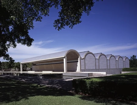
As of 2020, Tarrant County is the 3rd-most populous county in the state and the 15th-most populous county in the country. Its population growth is most likely due to the construction of the Texas and Pacific Railway that was completed in 1876. The county is swung between Democratic and Republican, but in the last recent decades, it was a Republican county. Visit the Arlington Heights Lodge, Kimbell Art Museum, Forth Worth Zoo, and the many other attractions in the county!
MIDDLESEX COUNTY (Noivern)
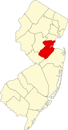
Middlesex County is a county located in north-central New Jersey. It is named after the historic English county of Middlesex. Its county seat is New Brunswick, though its largest township is Edison. It was founded on March 7, 1683.
(2022 Data)
Population: 861,418
Land Area: 309 mi2
Population Density: 2,788/mi2
Largest Age Range: 35-49
MHI: $102,073
Poverty Rate: 8.5%
Largest Source of Immigrants: India, Mexico
HISTORY
Before colonization, the Lenape (Delaware) people lived in present-day New Jersey, which included present-day Middlesex County. When settlers came to the area in the 17th century, most settlers settled near the Raritan River, mainly for its clay. The county was formed as one of the four administrative districts within the Province of East Jersey in 1675, along with Bergen, Essex, and Monmouth districts. Later, Middlesex County was formed on March 7, 1683.
MISC. AND FUN FACTS!
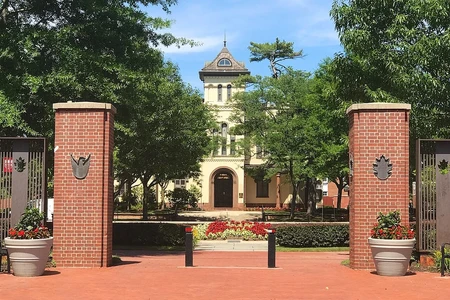
As of 2020, Middlesex County is New Jersey's third-most populous county, and it calls itself the Greatest County in the Land. Middlesex County is well known for its Indian population, home to Little India, a South-Asian community. Furthermore, Middlesex County has the largest Asian population in New Jersey. Election ballots in the county are printed not only in English and Spanish, but also Hindi, Punjabi, and Gujarati. The county is swung toward Democratic likely due to its urban population. The county is also home to the well-known Rutgers University. Visit the many parks in Middlesex County if you have the chance.
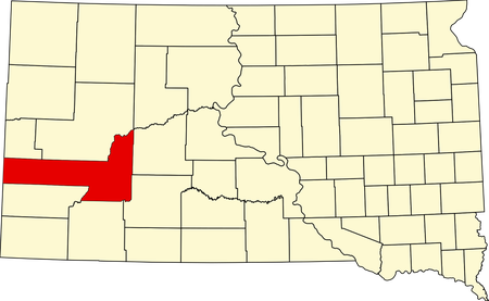
PENNINGTON COUNTY (FlabberBapper)
Pennington County is a county located in southwestern South Dakota. Its county seat and largest city is Rapid City, the second largest city in the state. It is named after John L. Pennington, the fifth governor of the Dakota Territory. It was created on January 11, 1875, but officially organized on April 19, 1877.
(2022 Data)
Population: 114,461
Land Area: 2,776.77 mi2
Population Density: 41.23/mi2
Largest Age Range: 50+
MHI: $67,573
Poverty Rate: 12%
Largest Source of Immigrants: Mexico, Philippines
HISTORY
Prior to European colonization, the land was inhabited by the Sioux, Cheyenne, and Crow tribes. When the U.S. expanded during the 19th century, George Custer, a U.S. army commander, led a group into present-day Pennington County, where they discovered Black Elk Peak, U.S.'s highest peak east of the Rockies. The group figured that gold could be found in this area, so a gold rush commenced in that area. Settlement was large enough to form a local government, so the county was created in 1875, and fully organized in 1877.
MISC AND FUN FACTS!
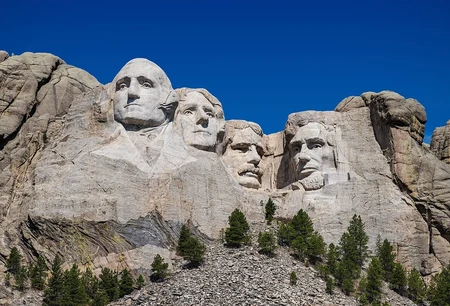
The county seat of Pennington County was initially Sheridan, but in 1878 it was moved to Rapid City. Sheridan would later become a ghost town and then get flooded by a dam. In Pennington County, you can find the well-known Mount Rushmore in Keystone, depicting the heads of U.S. presidents George Washington, Abraham Lincoln, Theodore Roosevelt, and Thomas Jefferson carved into a mountain. In 1923, Doane Robinson, superintendent of the South Dakota State Historical Society, had the idea to carve a massive sculpture in a mountain. With a dedication speech from president Calvin Coolidge, Robinson's dream became a reality and sculptor Gutzon Borglum began the sculpting in 1927. This massive sculpture that still stands today was completed in 1941. The county is swung toward Republican.
If you find yourself in this county, take a peek at Mount Rushmore, and the many historic places in the county.
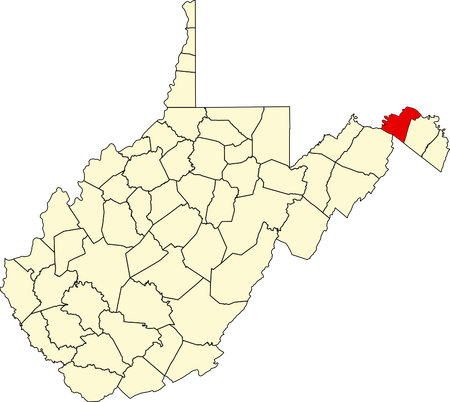
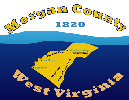
MORGAN COUNTY (Pontiac)
Morgan County is a county located in the eastern panhandle of West Virginia, being the third easternmost county in the state. Its county seat is Berkeley Springs, which happens to not be in Berkeley County (the county to the right of it). It was founded on February 9, 1820 and is named after Daniel Morgan, a Virginia politician.
(2022 Data)
Population: 17,430
Land Area: 229 mi2
Population Density: 76.1/mi2
Largest Age Range: 50+
MHI: $56,162
Poverty: 11% (2023)
Largest Source of Immigrants: Mexico
HISTORY
The first settlers arrived in the area during the 1730s. Most of them were unknown because they were squatters. News of the county's warm springs spread and Thomas Fairfax wanted the land to be surveyed.In 1748, a survey party was sent that included 16-year-old George Washington. After the survey, he returned to the town with his ill brother Lawrence. These springs and their alleged therapeutic values attracted many settlers of European and Native American origins. The town grew and the county became a popular destination for Virginia's social upper class. In October 1776, the town was officially named Bath after Bath, England. During and after the American Revolutionary War, the population increased significantly due to wounded soldiers coming to the warm springs believing their alleged healing properties. Bath was practically known as a town to party and be merry. Bath's name was changed to Berkeley Springs because the post office changed it to that to avoid confusion with another Virginian town named Bath, so the town followed suit. From an act of the Virginia General Assembly, portions of Berkeley and Hampshire counties were used to form Morgan County.
MISC. AND FUN FACTS!
The region is home to one of the country's important silica mines which are part of U.S. Silica. It also hosts the Apple Butter Festival which is usually held in October. On April 10, 1919, African-American Hugh Ferguson was accused of assaulting white lady near her home. A mob circled the jail Ferguson was residing in wanting to lynch Ferguson. What happened was that the sheriff fled the town with Ferguson. This was one of the many things that happened during the Morgan County race riots. It also has a pretty interesting flag. The county is swung toward Republican.
LINCOLN COUNTY (TigerNiger)
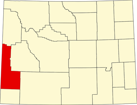
Lincoln County is a county located in Wyoming's southwest. Its county seat and largest city is Kemmerer. It is named after the 16th president of the U.S., Abraham Lincoln. It was founded on February 21, 1911 and organized in 1913.
(2022 Data)
Population: 20,660
Land Area: 4,076 mi2
Population Density: 5.06/mi2
Largest Age Range: 45-64
MHI: $101,763
Poverty Rate: 7.1% (2023)
Largest Source of Immigrants: Mexico
HISTORY
Before America expanded westward, many native peoples lived here, such as the Shoshone. The land was viewed as "uninhabitable," yet many came to settle here. In the early 1800s, fur trade expanded into the Rockies and mountain men (people who lived in the mountains hunting beavers) began to explore. In the 1820s, American fur trappers annually visited the region and continued doing so until the decline of the beaver trade by the 1840s. By the 1840s, many people crossed the continent for fertile land in Oregon, religious freedom in Utah, and gold in California. Many of the trails used crossed Lincoln County. In the late 1860s to 70s, many settlements began popping up in the area, such as Cokeville, settled from findings of copper, phosphorus, and coal. Settlers thereupon brought cattle and sheep into the area. Mass settlement started by 1878 when Mormons who wanted to practice their traditions without persecution after the Poland Act in 1874 searched for more remote areas, such as Lincoln County. Some of these Mormons established the town of Afton and continued to practice polygamy until the 20th century. Settlements continued to appear by the late 19th century, such as Kemmerer, a coal town founded by Patrick Quealy and Mahlon Kemmerer. Kemmerer was an independent coal town (meaning it wasn't operated by some company); as a result, many entrepreneurs and businessmen who weren't necessarily involved in the mining business purchased individual lots in Kemmerer. Kemmerer's population began to increase and it became the county seat of Lincoln County when it was founded on February 21, 1911.
MISC. AND FACTS
The county is swung toward Republican. Some of the cool landmarks you can find in Lincoln County are the Fossil Butte National Monument, the Cokeville Meadows National Wildlife Refuge, the J.C. Penney House, and the Haddenham Cabin. James Cash Penney opened his first store in Kemmerer and that laid the foundation of what would later become J.C. Penney, one of the U.S.'s biggest retail empires. On May 16, 1986, David and Doris Young walked into the Cokeville Elementary School and took the children and staff hostage. The Youngs brought a homemade bomb and weapons to the school and demanded a $300 million ransom of the 167 hostages. After two hours the bomb exploded, and David shot and wounded a teacher. He and his wife both took their lives thereafter. 76 children were hospitalized and the Youngs were the only deaths.
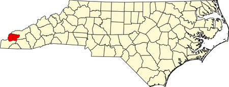
GRAHAM COUNTY (toowise)
Graham County is a county located in the far west of North Carolina. Its county seat and largest city is Robbinsville. It is named after William Graham, a senator and the Governor of North Carolina from 1845 to 1849. It was founded in 1872.
(2022 Data)
Population: 8,052
Land Area: 291.97 mi2
Population Density: 27.6/mi2
Largest Age Range: 45-64
MHI: $56,390
Poverty Rate: 8.7% (2023)
Largest Source of Immigrants: Mexico
HISTORY
Before white people came to settle, many Native American tribes lived in this area, such as the Cherokee. President Andrew Jackson opened up the land to settlement when he passed the Indian Removal Act in 1838. This act brought the first wagon road in the county when soldiers, who were under orders from Gen. Winfield Scott, moved into the area and built Fort Montgomery. A makeshift highway was built from Andrews to Fort Montgomery near Robbinsville to displace the Natives. Settlers eventually came to the area, such as Reverend Joseph Wiggins, a preacher, and Billy Crisp, son of Joel Crisp, a legislator. In 1843, the first post office was established. Soon in 1872, Graham County was finally founded and organized.
MISC. AND FUN FACTS
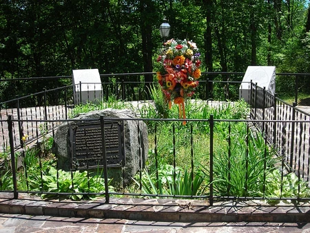
The county is heavily swung toward Republican. It is the third-least populous county in the state. Before 1914, there were disputed parts of Graham County that were claimed by Tennessee; the Supreme Court intervened and North Carolina eventually won the land. Junaluska, a Cherokee leader and warrior who saved Andrew Jackson's life at Horseshoe Bend, is buried in Graham County and has his own grave site at the Junaluska Memorial Site.
NASSAU COUNTY (jbro)
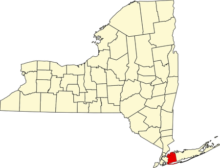
Nassau County is a county located on New York's Long Island adjacent to New York City. It is home to many of NYC's suburbs. Its county seat is Mineola, but its largest city is Hempstead. It is named after the aristocratic House of Nassau, and it was founded in 1899.
(2022 Data)
Population: 1,386,825
Land Area: 285 mi2
Population Density: 4,866/mi2
Largest Age Range: 45-64
MHI: $135,528
Poverty Rate: 5.3% (2023)
Largest Source of Immigrants: El Salvador, India, Dominican Republic
HISTORY
Before European settlers came, many Algonquian Natives lived near present-day Nassau County, such as the Matinecoc, the Marsapeque, and the Sacataogue. Then, Europeans came and settled the area. First, the Dutch came and claimed the area as part of New Netherland. Then, the English gained control in 1664 and the entirety of Long Island became part of the Province of New York. On November 1, 1683, the first twelve counties of New York were created. Present-day Nassau County was part of Queens County at that time. In 1784, after the American Revolution, the town of Hempstead was split in two. The Patriots seceded and made the town of North Hempstead, leaving the majority Loyalists in normal Hempstead. Somewhere around 1850, Queens County's western towns' population was much higher than the three eastern towns. The eastern and western towns were soon divided on where to put the new courthouse, since problems arose about the conditions of the old one and the hassle of travel. Eventually they did end up moving the county seat to Long Island City from Mineola around 1874. But then, the eastern towns' representatives were advocating for separation from the western towns. Then, in 1898, the western portion of Queens County became a borough of the City of Greater New York, leaving the eastern portion behind. This made the eastern portion part of Queens County, but not part of Queens Borough. As part of the city consolidation plan, any settlement's government within the borough was dissolved, leaving the governments of the eastern portion's towns (which were North Hempstead, Oyster Bay, and most of Hempstead) to be present. In 1899, the New York State Legislature gave the approval to the three towns to separate from Queens County and before that on November 1898, voters chose Mineola to be the county seat (even before it was incorporated as a village in 1906).
MISC. AND FUN FACTS!
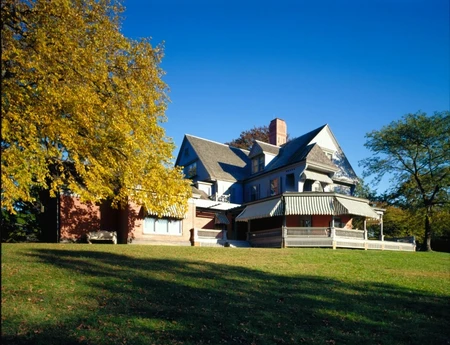
The county is sort of a "swing" county between Republican and Democratic. It is the second-most populated county in the state excluding New York City, and is the 29th most populated county in the country. There were some alternate names for Nassau County, such as Bryant, Matinecock, Norfolk, and Sagamore. However, Nassau stuck around because "Nassau" was once the name of Long Island itself and people started calling it "Nassau County" when it was proposed in 1875. The county bird is the osprey. During his presidency, Theodore Roosevelt lived in Oyster Bay in his estate, Sagamore Hill, which is now a US National Historic Site.
Epilogue
I hope you enjoyed and learned something for the eleventh blog of the series Hope you learned something about these counties, and try to do the U.S. county quiz (or something) :D
Currently, the counties I have yet to do are:
?? - The Washington Counties (Rockum99)
Who knows when the next one will come out...
Again, you can recommend a county and you'll be on the list!
I recommend Maui County and San Bernardino County
I have been thinking to allow the Alaskan boroughs and census areas though.
Can you do Grant County, WV?